Allen County Map, Ohio

Allen County Map Collection

We allow you to use our Allen County map. Attribution is required.
Allen County, Ohio

Allen County is in the middle of northwest Ohio. Lima is the county seat. It’s an industrial powerhouse with a rich history in oil production. The Lima Army Tank Plant has been churning out military vehicles for decades.
You’ll find a mix of urban and rural life here. The county is flat farmland stretches for miles. Local festivals bring the community together throughout the year.
Allen County has a strong sense of pride. It’s a place where people work hard and play hard. The Allen County Fair is a summer highlight that shouldn’t be missed.
| Category | Details |
|---|---|
| County Name | Allen County |
| County Seat | Lima |
| Population | Approximately 105,000 |
| Cities, Towns, and Communities | Lima, Delphos, Ada, Bluffton |
| Interstates and Highways | Interstate 75, U.S. Highway 30, State Route 65 |
| FIPS Code | 39-003 |
| Total Area | 402 square miles (land and water) |
| Adjacent Counties | Putnam County (North), Hancock County (Northeast), Hardin County (East), Auglaize County (South), Van Wert County (West) |
| Time Zone | Eastern Time Zone |
| State | Ohio |
| Coordinates | 40.7404° N, 84.1056° W |
| Etymology | Named after John Allen, a War of 1812 colonel |
| Major Landmarks | Allen County Museum, Lima’s Veterans Memorial Civic Center |
| Website | Allen County Website |
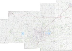
TRANSPORTATION MAP
Allen County Road Map
Interstate 75 cuts right through Allen County. It links Lima to cities far north and south. U.S. Route 30 also runs east-west across the northern half. Though it’s mostly flat farmland, these highways keep it well connected. You can explore it all by using our zoom tool below.

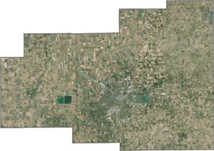
SATELLITE IMAGERY
Allen County Satellite Map
Much of Allen County is farms. But Lima stands out in the middle. Basically, it’s where all the roads and rail meet. Although fields dominate the view, industrial zones and suburbs around the city show up clearly. Roads form a neat grid, especially in rural zones. Still, wooded areas and ponds break up the geometry here and there.

OUTLINE MAP
Allen County Blank Map
Allen County forms a rough square, but it’s not perfectly shaped. It borders no other state, and no major river defines its edge. Straight lines mark most of the boundary, without the slightest curve.

Neighboring Counties
Here are the 5 neighboring counties of Allen County:


Ohio County Map

Forget the coast. Ohio’s 88 counties are where real America hums. No pretense, no postcard perfection, just hard-working towns and quiet backroads that get under your skin. This is the Midwest without the filter.