Washington County Map

Washington County Map Collection


We allow you to use our Washington County map. Attribution is required.
Washington County Maps
There are 39 counties in the Evergreen State, all placed in a diverse landscape. Click on a map below to see it up close and almost in person.


PHYSICAL MAP
Washington Topographic County Map
This map connects all the dots… county outlines, highways, cities, rivers, and lakes. If you want to see how Washington fits with its counties, this is the one.

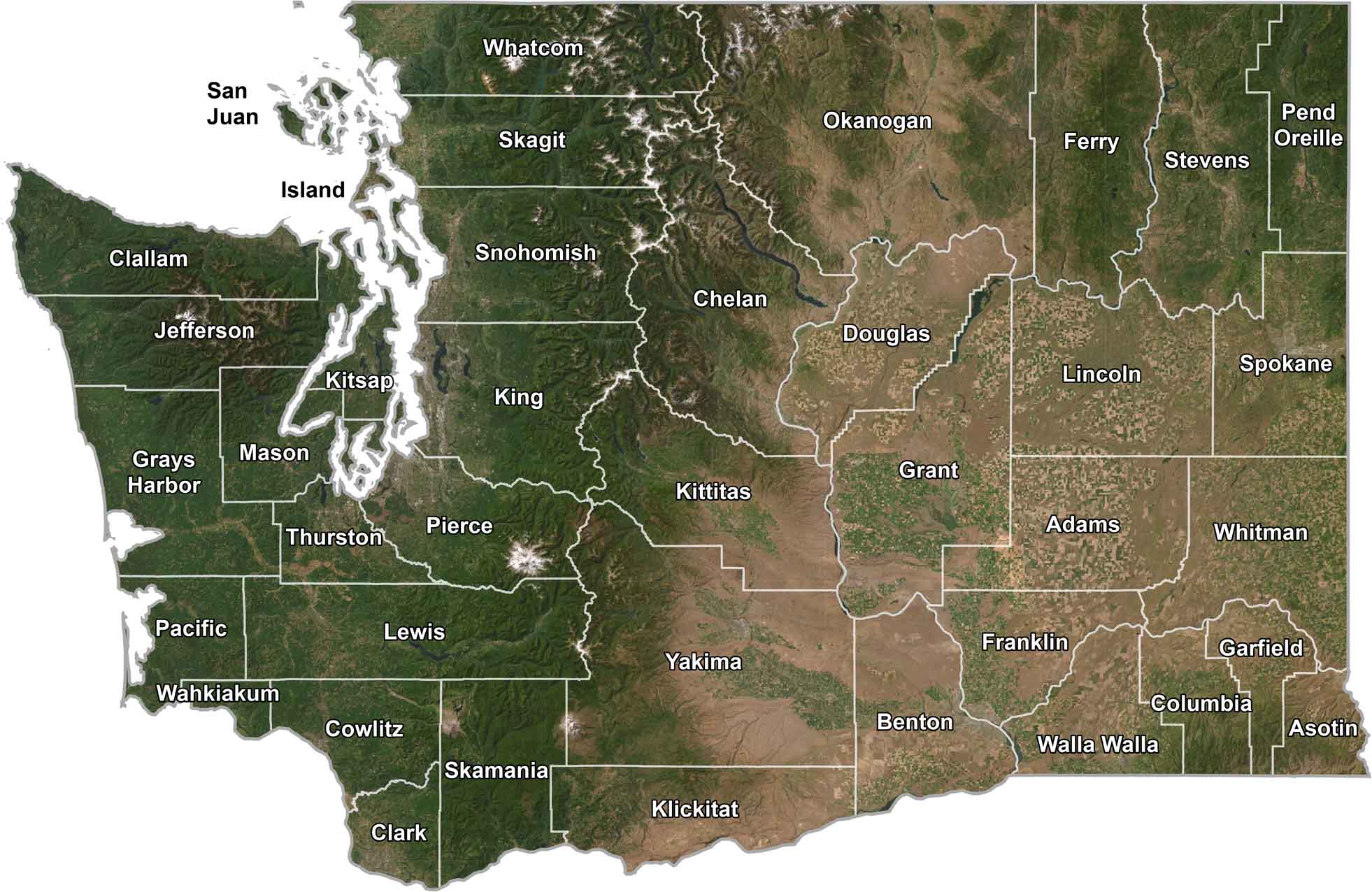
SATELLITE IMAGERY
Washington Satellite County Map
Washington is a wild mix of deep green forests, snowy mountains, dry stretches in the east, and coastlines cut with bays and sounds. County lines are added just enough to frame it without taking away from the natural beauty.
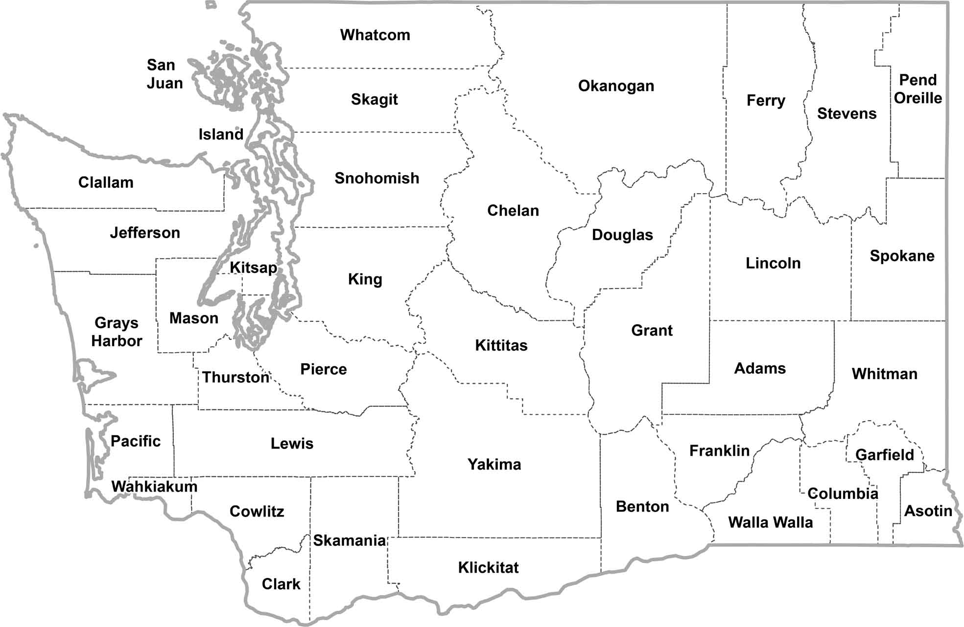
OUTLINE MAP
Washington Simple County Map
Here’s a simple county map of Washington. You’ll find county names and borders. Good for reference, great for simplicity.
Washington Counties
King County is the most populous county. It’s home to Seattle, the state’s largest city and a major tech hub. People come here for jobs at places like Amazon and Microsoft. Meanwhile, there’s Garfield County. It’s in the southeast, mostly wheat fields and rolling hills. In the latest census count, it had fewer than 2,500 people.
Most Populous: King County
Least Populous: Garfield County

Okanogan County has the biggest landmass, covering over 5,300 square miles. This county stretches from the Cascade Mountains to the Canadian border. It’s a mix of forests, farmland, and some pretty rugged terrain.
The smallest county is San Juan County, which is basically just a bunch of islands in Puget Sound. It’s only about 174 square miles, but it’s packed with scenic views and whale-watching spots.
Largest Area: Okanogan County
Smallest Area: San Juan County
The oldest county, Lewis County, was set up back in 1845 when Washington was still just a territory. The state’s counties also have some quirks. Pierce County got its name from the 14th U.S. President. Finally, Pend Oreille County is named after a Native American tribe but everyone pronounces it wrong.
Washington County List
Here’s a complete list of Washington’s counties. Find key statistics in the table below.
| FIPS Code | Name | Land % | Water % | Total Area (sq mi) |
|---|---|---|---|---|
| 53-001 | Adams County | 99.8 | 0.2 | 1,929.8 |
| 53-003 | Asotin County | 99.3 | 0.7 | 640.4 |
| 53-005 | Benton County | 96.6 | 3.4 | 1,759.7 |
| 53-007 | Chelan County | 97.6 | 2.4 | 2,994.4 |
| 53-009 | Clallam County | 65.1 | 34.9 | 2,670.7 |
| 53-011 | Clark County | 95.9 | 4.1 | 655.6 |
| 53-013 | Columbia County | 99.4 | 0.6 | 873.4 |
| 53-015 | Cowlitz County | 97.8 | 2.2 | 1,166.4 |
| 53-017 | Douglas County | 98.4 | 1.6 | 1,848.8 |
| 53-019 | Ferry County | 97.6 | 2.4 | 2,257.4 |
| 53-021 | Franklin County | 98.2 | 1.8 | 1,265.0 |
| 53-023 | Garfield County | 99.0 | 1.0 | 718.3 |
| 53-025 | Grant County | 96.0 | 4.0 | 2,791.4 |
| 53-027 | Grays Harbor County | 85.5 | 14.5 | 2,223.6 |
| 53-029 | Island County | 40.3 | 59.7 | 517.3 |
| 53-031 | Jefferson County | 82.4 | 17.6 | 2,187.9 |
| 53-033 | King County | 91.7 | 8.3 | 2,307.4 |
| 53-035 | Kitsap County | 69.8 | 30.2 | 565.8 |
| 53-037 | Kittitas County | 98.5 | 1.5 | 2,333.0 |
| 53-039 | Klickitat County | 98.3 | 1.7 | 1,904.4 |
| 53-041 | Lewis County | 98.6 | 1.4 | 2,436.3 |
| 53-043 | Lincoln County | 98.8 | 1.2 | 2,339.6 |
| 53-045 | Mason County | 91.3 | 8.7 | 1,051.0 |
| 53-047 | Okanogan County | 99.1 | 0.9 | 5,312.6 |
| 53-049 | Pacific County | 76.0 | 24.0 | 1,226.5 |
| 53-051 | Pend Oreille County | 98.2 | 1.8 | 1,425.5 |
| 53-053 | Pierce County | 92.4 | 7.6 | 1,805.4 |
| 53-055 | San Juan County | 28.0 | 72.0 | 620.8 |
| 53-057 | Skagit County | 90.3 | 9.7 | 1,917.0 |
| 53-059 | Skamania County | 98.3 | 1.7 | 1,686.6 |
| 53-061 | Snohomish County | 95.0 | 5.0 | 2,195.7 |
| 53-063 | Spokane County | 99.1 | 0.9 | 1,780.6 |
| 53-065 | Stevens County | 97.5 | 2.5 | 2,540.3 |
| 53-067 | Thurston County | 93.3 | 6.7 | 774.1 |
| 53-069 | Wahkiakum County | 91.7 | 8.3 | 286.7 |
| 53-071 | Walla Walla County | 97.8 | 2.2 | 1,299.0 |
| 53-073 | Whatcom County | 84.2 | 15.8 | 2,504.9 |
| 53-075 | Whitman County | 99.1 | 0.9 | 2,177.9 |
| 53-077 | Yakima County | 99.6 | 0.4 | 4,310.4 |
Source: United States Census Bureau
Thanks for these maps! We’re considering to Washington state and they’ve been very helpful.