Nebraska County Map

Nebraska County Map Collection
We allow you to use our Nebraska County map. Attribution is required.
Nebraska County Maps
Across the Cornhusker State, you’ll find 93 counties spread out over its prairies and plains.


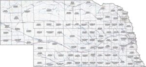
PHYSICAL MAP
Nebraska Topographic County Map
If you’re trying to get a handle on Nebraska’s layout, this map is a solid place to start. It has counties, highways, lakes, rivers, and much more.
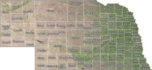
SATELLITE IMAGERY
Nebraska Satellite County Map
Nebraska has miles of fields, winding rivers, and the occasional town popping up. Our satellite map gives you the full picture, and we’ve added county lines to keep things organized.

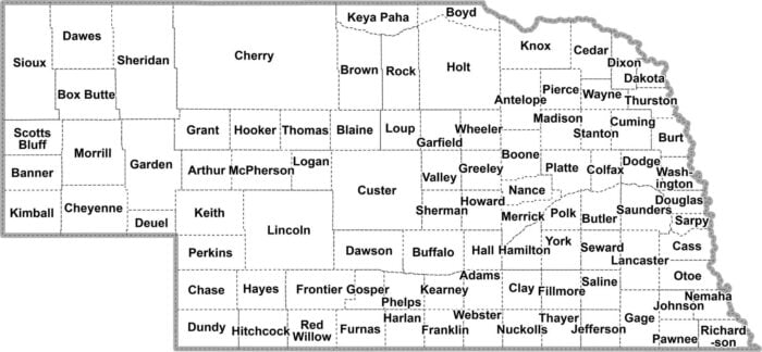
OUTLINE MAP
Nebraska Simple County Map
This one’s all about clarity. Nebraska, broken into counties with nothing extra. You’ll find just clean lines and names where they belong. Easy to scan, easier to use.

Nebraska Counties
In Nebraska, Douglas County is where most of the action is. It’s the most populous county, mainly because it’s home to Omaha, the state’s largest city. What’s the least populous county in Nebraska? Well, if you’re looking for some real solitude, head out to Arthur County in the Sandhills.
Most Populous: Douglas County
Least Populous: Arthur County

Cherry County takes the prize for size. It’s even bigger than Connecticut, if you can believe it. In terms of smallest county, there’s Sarpy County. But don’t let its size fool you though. It’s actually the third most populous county, thanks to its proximity to Omaha.
Largest Area: Cherry County
Smallest Area: Sarpy County
Nebraska started setting up counties pretty early on. The first eight were established in 1854, the same year Nebraska became a territory. They’ve continued using them ever since. The county origins can be unique at time. For example, Box Butte County is named after a distinctively shaped butte that early settlers used as a landmark. Or how about Hooker County? No, it’s not what you’re thinking. It’s named after a Civil War general.
Nebraska County List
Get to know Nebraska even more with our table and statistics:
| FIPS Code | Name | Land % | Water % | Total Area (sq mi) |
|---|---|---|---|---|
| 31-001 | Adams County | 99.8 | 0.2 | 564.2 |
| 31-003 | Antelope County | 99.8 | 0.2 | 858.6 |
| 31-005 | Arthur County | 99.6 | 0.4 | 718.3 |
| 31-007 | Banner County | 100.0 | 0.0 | 746.4 |
| 31-009 | Blaine County | 99.5 | 0.5 | 714.3 |
| 31-011 | Boone County | 99.9 | 0.1 | 687.2 |
| 31-013 | Box Butte County | 99.8 | 0.2 | 1,077.8 |
| 31-015 | Boyd County | 99.2 | 0.8 | 544.5 |
| 31-017 | Brown County | 99.7 | 0.3 | 1,225.1 |
| 31-019 | Buffalo County | 99.3 | 0.7 | 975.4 |
| 31-021 | Burt County | 98.9 | 1.1 | 497.1 |
| 31-023 | Butler County | 99.0 | 1.0 | 590.8 |
| 31-025 | Cass County | 98.5 | 1.5 | 565.9 |
| 31-027 | Cedar County | 99.2 | 0.8 | 745.8 |
| 31-029 | Chase County | 99.7 | 0.3 | 897.5 |
| 31-031 | Cherry County | 99.2 | 0.8 | 6,009.4 |
| 31-033 | Cheyenne County | 100.0 | 0.0 | 1,196.4 |
| 31-035 | Clay County | 99.8 | 0.2 | 573.5 |
| 31-037 | Colfax County | 98.8 | 1.2 | 416.5 |
| 31-039 | Cuming County | 99.3 | 0.7 | 574.6 |
| 31-041 | Custer County | 100.0 | 0.0 | 2,575.9 |
| 31-043 | Dakota County | 98.8 | 1.2 | 267.4 |
| 31-045 | Dawes County | 99.7 | 0.3 | 1,401.1 |
| 31-047 | Dawson County | 99.4 | 0.6 | 1,019.4 |
| 31-049 | Deuel County | 99.8 | 0.2 | 440.7 |
| 31-051 | Dixon County | 98.6 | 1.4 | 482.7 |
| 31-053 | Dodge County | 97.4 | 2.6 | 543.0 |
| 31-055 | Douglas County | 96.2 | 3.8 | 339.3 |
| 31-057 | Dundy County | 99.9 | 0.1 | 920.8 |
| 31-059 | Fillmore County | 99.8 | 0.2 | 576.5 |
| 31-061 | Franklin County | 100.0 | 0.0 | 576.0 |
| 31-063 | Frontier County | 99.4 | 0.6 | 980.1 |
| 31-065 | Furnas County | 99.8 | 0.2 | 720.6 |
| 31-067 | Gage County | 99.0 | 1.0 | 860.0 |
| 31-069 | Garden County | 98.5 | 1.5 | 1,730.9 |
| 31-071 | Garfield County | 99.6 | 0.4 | 571.4 |
| 31-073 | Gosper County | 99.0 | 1.0 | 462.7 |
| 31-075 | Grant County | 99.2 | 0.8 | 783.2 |
| 31-077 | Greeley County | 99.9 | 0.1 | 570.7 |
| 31-079 | Hall County | 99.0 | 1.0 | 552.1 |
| 31-081 | Hamilton County | 99.5 | 0.5 | 544.7 |
| 31-083 | Harlan County | 96.4 | 3.6 | 574.1 |
| 31-085 | Hayes County | 100.0 | 0.0 | 713.3 |
| 31-087 | Hitchcock County | 98.8 | 1.2 | 718.5 |
| 31-089 | Holt County | 99.8 | 0.2 | 2,417.5 |
| 31-091 | Hooker County | 100.0 | 0.0 | 721.5 |
| 31-093 | Howard County | 98.9 | 1.1 | 575.6 |
| 31-095 | Jefferson County | 99.0 | 1.0 | 575.7 |
| 31-097 | Johnson County | 99.8 | 0.2 | 376.7 |
| 31-099 | Kearney County | 100.0 | 0.0 | 516.3 |
| 31-101 | Keith County | 95.7 | 4.3 | 1,109.7 |
| 31-103 | Keya Paha County | 99.9 | 0.1 | 773.9 |
| 31-105 | Kimball County | 99.9 | 0.1 | 952.4 |
| 31-107 | Knox County | 97.3 | 2.7 | 1,139.7 |
| 31-109 | Lancaster County | 99.0 | 1.0 | 846.4 |
| 31-111 | Lincoln County | 99.6 | 0.4 | 2,575.1 |
| 31-113 | Logan County | 99.9 | 0.1 | 571.1 |
| 31-115 | Loup County | 98.7 | 1.3 | 571.1 |
| 31-117 | McPherson County | 99.9 | 0.1 | 860.0 |
| 31-119 | Madison County | 99.5 | 0.5 | 575.4 |
| 31-121 | Merrick County | 97.8 | 2.2 | 496.8 |
| 31-123 | Morrill County | 99.6 | 0.4 | 1,429.9 |
| 31-125 | Nance County | 98.5 | 1.5 | 448.2 |
| 31-127 | Nemaha County | 99.5 | 0.5 | 409.6 |
| 31-129 | Nuckolls County | 99.9 | 0.1 | 575.8 |
| 31-131 | Otoe County | 99.5 | 0.5 | 619.0 |
| 31-133 | Pawnee County | 99.6 | 0.4 | 432.9 |
| 31-135 | Perkins County | 99.9 | 0.1 | 884.4 |
| 31-137 | Phelps County | 99.9 | 0.1 | 540.4 |
| 31-139 | Pierce County | 99.8 | 0.2 | 574.6 |
| 31-141 | Platte County | 98.5 | 1.5 | 684.6 |
| 31-143 | Polk County | 99.5 | 0.5 | 440.6 |
| 31-145 | Red Willow County | 99.9 | 0.1 | 718.0 |
| 31-147 | Richardson County | 99.5 | 0.5 | 554.6 |
| 31-149 | Rock County | 99.7 | 0.3 | 1,011.7 |
| 31-151 | Saline County | 99.6 | 0.4 | 576.3 |
| 31-153 | Sarpy County | 96.2 | 3.8 | 247.5 |
| 31-155 | Saunders County | 98.7 | 1.3 | 759.8 |
| 31-157 | Scotts Bluff County | 99.2 | 0.8 | 745.4 |
| 31-159 | Seward County | 99.2 | 0.8 | 575.9 |
| 31-161 | Sheridan County | 98.8 | 1.2 | 2,469.8 |
| 31-163 | Sherman County | 99.0 | 1.0 | 571.6 |
| 31-165 | Sioux County | 100.0 | 0.0 | 2,067.3 |
| 31-167 | Stanton County | 99.2 | 0.8 | 431.0 |
| 31-169 | Thayer County | 99.8 | 0.2 | 575.0 |
| 31-171 | Thomas County | 99.9 | 0.1 | 713.7 |
| 31-173 | Thurston County | 99.4 | 0.6 | 396.1 |
| 31-175 | Valley County | 99.6 | 0.4 | 570.5 |
| 31-177 | Washington County | 99.2 | 0.8 | 393.2 |
| 31-179 | Wayne County | 99.9 | 0.1 | 443.3 |
| 31-181 | Webster County | 100.0 | 0.0 | 575.0 |
| 31-183 | Wheeler County | 99.9 | 0.1 | 575.6 |
| 31-185 | York County | 99.4 | 0.6 | 575.8 |
Source: United States Census Bureau