South Dakota County Map

South Dakota County Map Collection


We allow you to use our South Dakota County map. Attribution is required.
South Dakota County Maps
There are 66 counties in the Mount Rushmore State. Check them all out with great detail by clicking a county map below.


PHYSICAL MAP
South Dakota Topographic County Map
Want to know where everything sits in South Dakota? This map spells it out. It displays county lines, highways slicing through the plains, towns and cities, plus lakes and rivers too.

SATELLITE IMAGERY
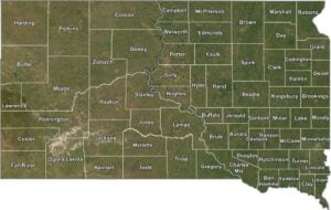
South Dakota Satellite County Map
South Dakota from above looks raw and open. Our satellite map keeps that natural feel while adding county borders. This way, you can still see the wide prairies, scattered hills, and rivers cutting clean through the land.

OUTLINE MAP
South Dakota Simple County Map
No fluff, no extras. Just South Dakota, county by county. Clean labels, clear lines. Easy to read, even easier to print out.

South Dakota Counties
In terms of population, Minnehaha County has the most people. It’s home to Sioux Falls, the state’s largest city. But for least populated, that would be Jones County. It’s out in the middle of the state, where the land is dry and the towns are few.
Most Populous: Minnehaha County
Least Populous: Jones County

When it comes to size, Meade County is the largest. It covers over 3,400 square miles with a good chunk of it taken up by the Black Hills National Forest. The smallest county is Clay County, clocking in at just 412 square miles.
Largest Area: Meade County
Smallest Area: Clay County
The first counties were set up back in 1861 when Dakota was still a territory. Some counties have changed shape over time as new ones were carved out. The quirkiest county is Shannon County, which recently changed its name to Oglala Lakota County to honor the Native American tribe that lives there.
South Dakota County List
Looking for a list of all of South Dakota’s counties. Read directly below.
| FIPS Code | Name | Land % | Water % | Total Area (sq mi) |
|---|---|---|---|---|
| 46-003 | Aurora County | 99.4 | 0.6 | 712.8 |
| 46-005 | Beadle County | 99.5 | 0.5 | 1,264.8 |
| 46-007 | Bennett County | 99.5 | 0.5 | 1,190.4 |
| 46-009 | Bon Homme County | 96.9 | 3.1 | 581.6 |
| 46-011 | Brookings County | 98.4 | 1.6 | 804.9 |
| 46-013 | Brown County | 99.0 | 1.0 | 1,730.9 |
| 46-015 | Brule County | 96.5 | 3.5 | 846.5 |
| 46-017 | Buffalo County | 96.6 | 3.4 | 487.8 |
| 46-019 | Butte County | 99.3 | 0.7 | 2,266.5 |
| 46-021 | Campbell County | 95.2 | 4.8 | 770.8 |
| 46-023 | Charles Mix County | 95.4 | 4.6 | 1,150.2 |
| 46-025 | Clark County | 99.0 | 1.0 | 967.5 |
| 46-027 | Clay County | 98.7 | 1.3 | 417.4 |
| 46-029 | Codington County | 95.9 | 4.1 | 717.2 |
| 46-031 | Corson County | 97.6 | 2.4 | 2,529.6 |
| 46-033 | Custer County | 99.9 | 0.1 | 1,559.1 |
| 46-035 | Davison County | 99.7 | 0.3 | 436.9 |
| 46-037 | Day County | 94.3 | 5.7 | 1,091.1 |
| 46-039 | Deuel County | 97.8 | 2.2 | 636.6 |
| 46-041 | Dewey County | 94.2 | 5.8 | 2,445.3 |
| 46-043 | Douglas County | 99.6 | 0.4 | 433.7 |
| 46-045 | Edmunds County | 97.8 | 2.2 | 1,151.1 |
| 46-047 | Fall River County | 99.5 | 0.5 | 1,749.2 |
| 46-049 | Faulk County | 97.6 | 2.4 | 1,005.9 |
| 46-051 | Grant County | 99.1 | 0.9 | 687.5 |
| 46-053 | Gregory County | 96.3 | 3.7 | 1,053.5 |
| 46-055 | Haakon County | 99.1 | 0.9 | 1,826.9 |
| 46-057 | Hamlin County | 94.3 | 5.7 | 538.1 |
| 46-059 | Hand County | 99.8 | 0.2 | 1,440.2 |
| 46-061 | Hanson County | 99.8 | 0.2 | 435.4 |
| 46-063 | Harding County | 99.8 | 0.2 | 2,678.1 |
| 46-065 | Hughes County | 92.6 | 7.4 | 800.7 |
| 46-067 | Hutchinson County | 99.8 | 0.2 | 814.4 |
| 46-069 | Hyde County | 99.4 | 0.6 | 866.2 |
| 46-071 | Jackson County | 99.6 | 0.4 | 1,871.2 |
| 46-073 | Jerauld County | 98.8 | 1.2 | 532.6 |
| 46-075 | Jones County | 99.9 | 0.1 | 970.9 |
| 46-077 | Kingsbury County | 96.4 | 3.6 | 863.8 |
| 46-079 | Lake County | 97.9 | 2.1 | 575.2 |
| 46-081 | Lawrence County | 100.0 | 0.0 | 800.3 |
| 46-083 | Lincoln County | 99.9 | 0.1 | 577.7 |
| 46-085 | Lyman County | 96.2 | 3.8 | 1,706.9 |
| 46-087 | McCook County | 99.5 | 0.5 | 576.9 |
| 46-089 | McPherson County | 98.7 | 1.3 | 1,151.5 |
| 46-091 | Marshall County | 94.6 | 5.4 | 886.2 |
| 46-093 | Meade County | 99.7 | 0.3 | 3,482.8 |
| 46-095 | Mellette County | 99.7 | 0.3 | 1,310.9 |
| 46-097 | Miner County | 99.7 | 0.3 | 571.9 |
| 46-099 | Minnehaha County | 99.1 | 0.9 | 813.9 |
| 46-101 | Moody County | 99.7 | 0.3 | 520.8 |
| 46-102 | Oglala Lakota County | 99.9 | 0.1 | 2,096.3 |
| 46-103 | Pennington County | 99.7 | 0.3 | 2,784.4 |
| 46-105 | Perkins County | 99.3 | 0.7 | 2,890.0 |
| 46-107 | Potter County | 95.8 | 4.2 | 898.7 |
| 46-109 | Roberts County | 96.9 | 3.1 | 1,135.8 |
| 46-111 | Sanborn County | 99.8 | 0.2 | 570.4 |
| 46-115 | Spink County | 99.6 | 0.4 | 1,509.7 |
| 46-117 | Stanley County | 95.2 | 4.8 | 1,517.2 |
| 46-119 | Sully County | 94.1 | 5.9 | 1,070.2 |
| 46-121 | Todd County | 99.8 | 0.2 | 1,390.8 |
| 46-123 | Tripp County | 99.7 | 0.3 | 1,617.6 |
| 46-125 | Turner County | 99.9 | 0.1 | 617.7 |
| 46-127 | Union County | 98.6 | 1.4 | 467.1 |
| 46-129 | Walworth County | 95.2 | 4.8 | 744.6 |
| 46-135 | Yankton County | 97.9 | 2.1 | 532.3 |
| 46-137 | Ziebach County | 99.5 | 0.5 | 1,970.6 |
Source: United States Census Bureau