New York County Map

New York County Map Collection

We allow you to use our New York County map. Attribution is required.
New York County Maps
New York State is carved up into 62 counties. Click on one of our maps below to find out more about its geography.


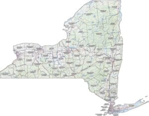
PHYSICAL MAP
New York Topographic County Map
Think New York is just the city? This map reminds you there’s a whole lot more. It shows all the counties, from the Adirondacks to Long Island. Plus, you’ll find major roads, cities, rivers, lakes, etc.

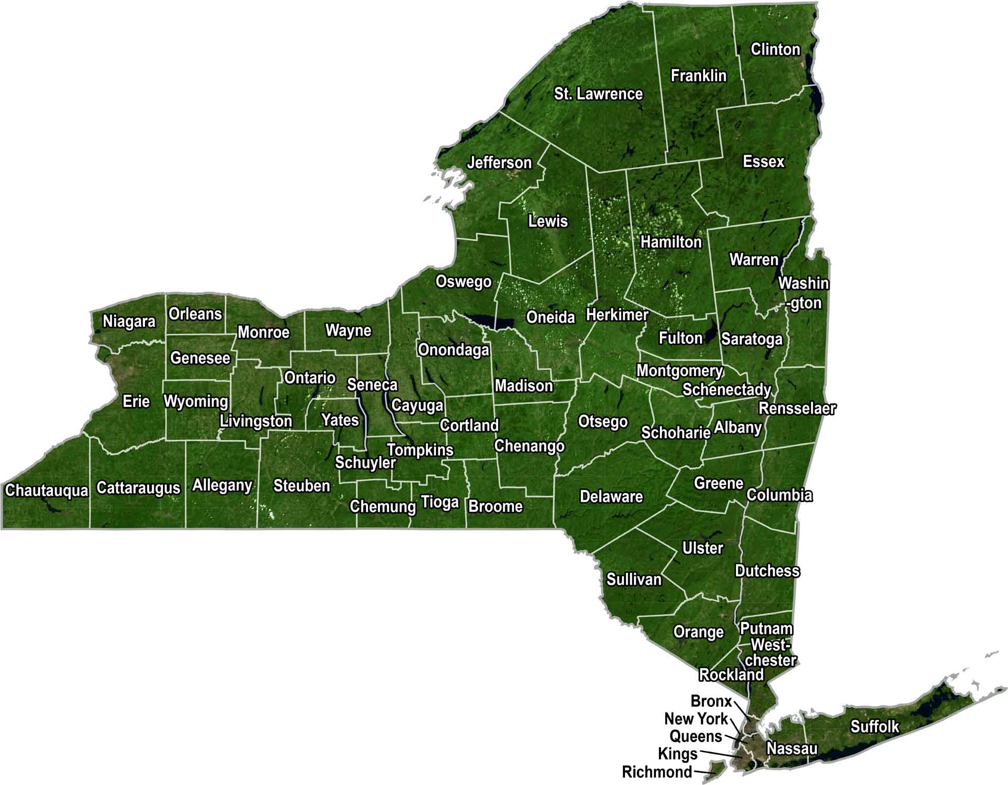
SATELLITE IMAGERY
New York Satellite County Map
From way up high, you’ll notice that New York has farms out west, concrete down south, and forest that fills the rest. Our satellite map keeps it natural with county lines and labels.
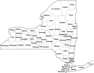
OUTLINE MAP
New York Simple County Map
No distractions, no clutter. Just New York, county by county, laid out in a way that makes sense. Scan it in five seconds or stare at it all day. Your call.

New York Counties
Kings County (that’s Brooklyn to most folks) is the most populated in the state of New York. It has more people than most states, packed into one borough. Hamilton County has the least populous with fewer year-round residents than some NYC apartment buildings.
Most Populous: Kings County
Least Populous: Hamilton County

In terms of land area, St. Lawrence County is the biggest. It’s actually bigger than the entire state of Delaware, if you can believe it. Meanwhile, the smallest county is New York County, better known as Manhattan. It might be tiny, but it packs more per square inch than anywhere else in the country.
Largest Area: St. Lawrence County
Smallest Area: New York County
New York started divvying up into counties way back in 1683 when it was still a British colony. Each county is different. Onondaga County is named after the Native American nation and means “people of the hills.” There’s also Rockland County, which got its name from all the, you guessed it, rocks found there by early Dutch settlers.
New York County List
Check out our table with all of New York’s counties including attributes of each one:
| FIPS Code | Name | Land % | Water % | Total Area (sq mi) |
|---|---|---|---|---|
| 36-001 | Albany County | 98.0 | 2.0 | 533.3 |
| 36-003 | Allegany County | 99.5 | 0.5 | 1,034.4 |
| 36-005 | Bronx County | 73.3 | 26.7 | 57.4 |
| 36-007 | Broome County | 98.6 | 1.4 | 715.5 |
| 36-009 | Cattaraugus County | 98.9 | 1.1 | 1,322.5 |
| 36-011 | Cayuga County | 80.1 | 19.9 | 863.7 |
| 36-013 | Chautauqua County | 70.7 | 29.3 | 1,500.2 |
| 36-015 | Chemung County | 99.2 | 0.8 | 410.8 |
| 36-017 | Chenango County | 99.4 | 0.6 | 898.6 |
| 36-019 | Clinton County | 92.9 | 7.1 | 1,117.5 |
| 36-021 | Columbia County | 97.9 | 2.1 | 648.2 |
| 36-023 | Cortland County | 99.5 | 0.5 | 501.5 |
| 36-025 | Delaware County | 98.3 | 1.7 | 1,467.4 |
| 36-027 | Dutchess County | 96.4 | 3.6 | 825.3 |
| 36-029 | Erie County | 85.0 | 15.0 | 1,226.8 |
| 36-031 | Essex County | 93.6 | 6.4 | 1,916.3 |
| 36-033 | Franklin County | 96.0 | 4.0 | 1,697.4 |
| 36-035 | Fulton County | 93.0 | 7.0 | 532.9 |
| 36-037 | Genesee County | 99.5 | 0.5 | 495.3 |
| 36-039 | Greene County | 98.3 | 1.7 | 658.0 |
| 36-041 | Hamilton County | 95.0 | 5.0 | 1,807.8 |
| 36-043 | Herkimer County | 96.8 | 3.2 | 1,458.0 |
| 36-045 | Jefferson County | 68.3 | 31.7 | 1,857.3 |
| 36-047 | Kings County | 71.6 | 28.4 | 96.8 |
| 36-049 | Lewis County | 98.8 | 1.2 | 1,289.9 |
| 36-051 | Livingston County | 98.7 | 1.3 | 640.3 |
| 36-053 | Madison County | 99.0 | 1.0 | 661.3 |
| 36-055 | Monroe County | 48.1 | 51.9 | 1,366.7 |
| 36-057 | Montgomery County | 98.2 | 1.8 | 410.3 |
| 36-059 | Nassau County | 62.8 | 37.2 | 453.5 |
| 36-061 | New York County | 67.3 | 32.7 | 33.7 |
| 36-063 | Niagara County | 45.8 | 54.2 | 1,139.7 |
| 36-065 | Oneida County | 96.4 | 3.6 | 1,257.6 |
| 36-067 | Onondaga County | 96.6 | 3.4 | 805.6 |
| 36-069 | Ontario County | 97.2 | 2.8 | 662.5 |
| 36-071 | Orange County | 96.9 | 3.1 | 838.6 |
| 36-073 | Orleans County | 47.9 | 52.1 | 817.4 |
| 36-075 | Oswego County | 72.5 | 27.5 | 1,312.1 |
| 36-077 | Otsego County | 98.6 | 1.4 | 1,015.8 |
| 36-079 | Putnam County | 93.5 | 6.5 | 246.2 |
| 36-081 | Queens County | 61.1 | 38.9 | 178.0 |
| 36-083 | Rensselaer County | 98.1 | 1.9 | 665.4 |
| 36-085 | Richmond County | 56.2 | 43.8 | 102.3 |
| 36-087 | Rockland County | 87.0 | 13.0 | 199.3 |
| 36-089 | St. Lawrence County | 95.0 | 5.0 | 2,821.3 |
| 36-091 | Saratoga County | 96.0 | 4.0 | 843.8 |
| 36-093 | Schenectady County | 97.7 | 2.3 | 209.4 |
| 36-095 | Schoharie County | 99.3 | 0.7 | 626.3 |
| 36-097 | Schuyler County | 95.9 | 4.1 | 342.3 |
| 36-099 | Seneca County | 82.9 | 17.1 | 390.4 |
| 36-101 | Steuben County | 99.0 | 1.0 | 1,404.1 |
| 36-103 | Suffolk County | 38.4 | 61.6 | 2,373.1 |
| 36-105 | Sullivan County | 97.1 | 2.9 | 996.7 |
| 36-107 | Tioga County | 99.2 | 0.8 | 522.9 |
| 36-109 | Tompkins County | 96.6 | 3.4 | 491.5 |
| 36-111 | Ulster County | 96.9 | 3.1 | 1,160.8 |
| 36-113 | Warren County | 93.1 | 6.9 | 931.6 |
| 36-115 | Washington County | 98.3 | 1.7 | 845.9 |
| 36-117 | Wayne County | 43.7 | 56.3 | 1,383.0 |
| 36-119 | Westchester County | 86.1 | 13.9 | 500.0 |
| 36-121 | Wyoming County | 99.4 | 0.6 | 596.3 |
| 36-123 | Yates County | 90.0 | 10.0 | 375.8 |
Source: United States Census Bureau