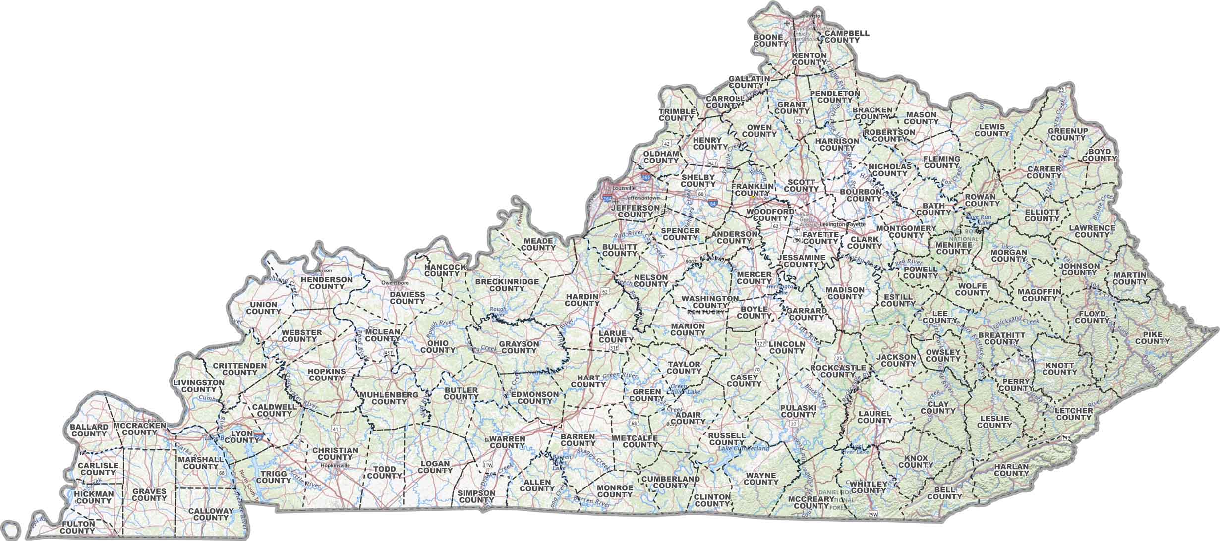
Kentucky County Map

Kentucky County Map Collection
We allow you to use our Kentucky County map. Attribution is required.
Kentucky County Maps
Kentucky is home to 120 counties, making it third in count to only to Texas and Georgia. Please note the Virginia has 133 counties and includes independent cities.


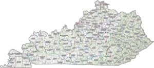
PHYSICAL MAP
Kentucky Topographic County Map
Take a look at Kentucky’s county layout with our topographic map. It shows county lines, major highways, and natural landmarks.
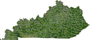
SATELLITE IMAGERY
Kentucky Satellite County Map
Kentucky’s mix of green forests, winding rivers, and small towns really stands out from above. Our satellite map highlights the Bluegrass State’s varied terrain and county boundaries.

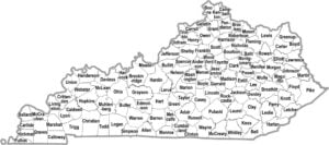
OUTLINE MAP
Kentucky Simple County Map
This simple map of Kentucky breaks the state down by county. You get to see how the state is divided in simple black and white.

Kentucky Counties
Jefferson County, which includes Louisville, is the most populous in Kentucky. It boasts a population that dwarfs most other counties in the state. On the other hand, Robertson County is the least populous. Located in northeastern Kentucky, it’s mostly rural without any major communities.
Most Populous: Jefferson County
Least Populous: Robertson County

When it comes to size, Pike County takes the lead as the largest in Kentucky. It covers over 780 square miles, including a large section of the Appalachian Mountains. Conversely, Gallatin County is the smallest in landmass, with only about 100 square miles of land.
Largest Area: Pike County
Smallest Area: Gallatin County
Kentucky’s counties are named after early American statesmen, Revolutionary War heroes, and Native American tribes. Fayette County, for instance, is named after the Marquis de Lafayette, a French aristocrat who supported the American Revolution. The first county in Kentucky, Fayette County, was established in 1780 when Kentucky was still part of Virginia.
Kentucky County List
Our table below of Kentucky counties is handy to learn about its area and FIPS code:
| FIPS Code | Name | Land % | Water % | Total Area (sq mi) |
|---|---|---|---|---|
| 21-001 | Adair County | 98.3 | 1.7 | 412.4 |
| 21-003 | Allen County | 97.9 | 2.1 | 351.9 |
| 21-005 | Anderson County | 98.9 | 1.1 | 204.3 |
| 21-007 | Ballard County | 90.2 | 9.8 | 273.7 |
| 21-009 | Barren County | 97.5 | 2.5 | 500.0 |
| 21-011 | Bath County | 98.2 | 1.8 | 284.0 |
| 21-013 | Bell County | 99.4 | 0.6 | 361.1 |
| 21-015 | Boone County | 96.0 | 4.0 | 256.5 |
| 21-017 | Bourbon County | 99.4 | 0.6 | 291.6 |
| 21-019 | Boyd County | 98.7 | 1.3 | 162.0 |
| 21-021 | Boyle County | 98.6 | 1.4 | 182.8 |
| 21-023 | Bracken County | 97.0 | 3.0 | 208.9 |
| 21-025 | Breathitt County | 99.4 | 0.6 | 495.3 |
| 21-027 | Breckinridge County | 97.3 | 2.7 | 585.6 |
| 21-029 | Bullitt County | 98.9 | 1.1 | 300.3 |
| 21-031 | Butler County | 98.8 | 1.2 | 431.5 |
| 21-033 | Caldwell County | 99.0 | 1.0 | 348.1 |
| 21-035 | Calloway County | 93.8 | 6.2 | 410.7 |
| 21-037 | Campbell County | 94.9 | 5.1 | 159.4 |
| 21-039 | Carlisle County | 95.2 | 4.8 | 199.0 |
| 21-041 | Carroll County | 93.6 | 6.4 | 137.3 |
| 21-043 | Carter County | 99.4 | 0.6 | 412.1 |
| 21-045 | Casey County | 99.7 | 0.3 | 445.7 |
| 21-047 | Christian County | 99.1 | 0.9 | 724.0 |
| 21-049 | Clark County | 99.0 | 1.0 | 255.2 |
| 21-051 | Clay County | 99.6 | 0.4 | 471.1 |
| 21-053 | Clinton County | 96.0 | 4.0 | 205.4 |
| 21-055 | Crittenden County | 97.0 | 3.0 | 371.1 |
| 21-057 | Cumberland County | 98.2 | 1.8 | 310.9 |
| 21-059 | Daviess County | 96.2 | 3.8 | 476.6 |
| 21-061 | Edmonson County | 98.3 | 1.7 | 308.0 |
| 21-063 | Elliott County | 99.6 | 0.4 | 235.3 |
| 21-065 | Estill County | 99.0 | 1.0 | 255.6 |
| 21-067 | Fayette County | 99.3 | 0.7 | 285.5 |
| 21-069 | Fleming County | 99.2 | 0.8 | 351.3 |
| 21-071 | Floyd County | 99.4 | 0.6 | 395.7 |
| 21-073 | Franklin County | 98.0 | 2.0 | 212.0 |
| 21-075 | Fulton County | 89.3 | 10.7 | 230.7 |
| 21-077 | Gallatin County | 93.9 | 6.1 | 104.7 |
| 21-079 | Garrard County | 98.4 | 1.6 | 233.9 |
| 21-081 | Grant County | 98.9 | 1.1 | 260.8 |
| 21-083 | Graves County | 99.1 | 0.9 | 556.8 |
| 21-085 | Grayson County | 97.8 | 2.2 | 511.0 |
| 21-087 | Green County | 99.1 | 0.9 | 288.8 |
| 21-089 | Greenup County | 97.2 | 2.8 | 354.5 |
| 21-091 | Hancock County | 94.4 | 5.6 | 198.9 |
| 21-093 | Hardin County | 98.9 | 1.1 | 630.1 |
| 21-095 | Harlan County | 99.5 | 0.5 | 468.1 |
| 21-097 | Harrison County | 98.9 | 1.1 | 309.9 |
| 21-099 | Hart County | 98.7 | 1.3 | 417.8 |
| 21-101 | Henderson County | 93.7 | 6.3 | 466.0 |
| 21-103 | Henry County | 98.3 | 1.7 | 291.1 |
| 21-105 | Hickman County | 95.7 | 4.3 | 253.0 |
| 21-107 | Hopkins County | 97.8 | 2.2 | 554.4 |
| 21-109 | Jackson County | 99.6 | 0.4 | 346.5 |
| 21-111 | Jefferson County | 95.7 | 4.3 | 397.7 |
| 21-113 | Jessamine County | 98.6 | 1.4 | 174.5 |
| 21-115 | Johnson County | 99.2 | 0.8 | 264.1 |
| 21-117 | Kenton County | 97.6 | 2.4 | 164.3 |
| 21-119 | Knott County | 99.6 | 0.4 | 352.8 |
| 21-121 | Knox County | 99.6 | 0.4 | 387.7 |
| 21-123 | Larue County | 99.2 | 0.8 | 263.6 |
| 21-125 | Laurel County | 97.8 | 2.2 | 443.7 |
| 21-127 | Lawrence County | 98.9 | 1.1 | 420.1 |
| 21-129 | Lee County | 98.9 | 1.1 | 211.3 |
| 21-131 | Leslie County | 99.1 | 0.9 | 404.4 |
| 21-133 | Letcher County | 99.7 | 0.3 | 339.0 |
| 21-135 | Lewis County | 97.5 | 2.5 | 495.4 |
| 21-137 | Lincoln County | 98.9 | 1.1 | 336.4 |
| 21-139 | Livingston County | 91.5 | 8.5 | 342.3 |
| 21-141 | Logan County | 99.1 | 0.9 | 557.0 |
| 21-143 | Lyon County | 83.4 | 16.6 | 256.5 |
| 21-145 | McCracken County | 92.8 | 7.2 | 268.2 |
| 21-147 | McCreary County | 99.0 | 1.0 | 430.9 |
| 21-149 | McLean County | 98.6 | 1.4 | 256.2 |
| 21-151 | Madison County | 98.7 | 1.3 | 443.3 |
| 21-153 | Magoffin County | 99.8 | 0.2 | 309.2 |
| 21-155 | Marion County | 98.9 | 1.1 | 346.9 |
| 21-157 | Marshall County | 88.6 | 11.4 | 340.2 |
| 21-159 | Martin County | 99.6 | 0.4 | 230.6 |
| 21-161 | Mason County | 97.4 | 2.6 | 246.4 |
| 21-163 | Meade County | 94.1 | 5.9 | 324.5 |
| 21-165 | Menifee County | 98.9 | 1.1 | 205.9 |
| 21-167 | Mercer County | 98.3 | 1.7 | 253.3 |
| 21-169 | Metcalfe County | 99.5 | 0.5 | 291.2 |
| 21-171 | Monroe County | 99.2 | 0.8 | 332.1 |
| 21-173 | Montgomery County | 99.3 | 0.7 | 198.8 |
| 21-175 | Morgan County | 99.3 | 0.7 | 383.8 |
| 21-177 | Muhlenberg County | 97.5 | 2.5 | 479.4 |
| 21-179 | Nelson County | 98.5 | 1.5 | 424.1 |
| 21-181 | Nicholas County | 99.2 | 0.8 | 196.8 |
| 21-183 | Ohio County | 98.5 | 1.5 | 596.2 |
| 21-185 | Oldham County | 95.3 | 4.7 | 196.4 |
| 21-187 | Owen County | 99.1 | 0.9 | 354.2 |
| 21-189 | Owsley County | 99.6 | 0.4 | 198.3 |
| 21-191 | Pendleton County | 98.3 | 1.7 | 281.9 |
| 21-193 | Perry County | 99.1 | 0.9 | 342.6 |
| 21-195 | Pike County | 99.8 | 0.2 | 788.6 |
| 21-197 | Powell County | 99.4 | 0.6 | 180.1 |
| 21-199 | Pulaski County | 97.2 | 2.8 | 677.2 |
| 21-201 | Robertson County | 99.8 | 0.2 | 100.1 |
| 21-203 | Rockcastle County | 99.5 | 0.5 | 318.1 |
| 21-205 | Rowan County | 97.8 | 2.2 | 286.3 |
| 21-207 | Russell County | 89.7 | 10.3 | 282.9 |
| 21-209 | Scott County | 98.7 | 1.3 | 285.4 |
| 21-211 | Shelby County | 98.5 | 1.5 | 385.7 |
| 21-213 | Simpson County | 99.0 | 1.0 | 236.5 |
| 21-215 | Spencer County | 97.4 | 2.6 | 191.7 |
| 21-217 | Taylor County | 96.2 | 3.8 | 276.8 |
| 21-219 | Todd County | 99.3 | 0.7 | 377.1 |
| 21-221 | Trigg County | 91.7 | 8.3 | 481.3 |
| 21-223 | Trimble County | 97.1 | 2.9 | 156.2 |
| 21-225 | Union County | 94.4 | 5.6 | 363.4 |
| 21-227 | Warren County | 98.9 | 1.1 | 547.6 |
| 21-229 | Washington County | 98.6 | 1.4 | 301.2 |
| 21-231 | Wayne County | 94.6 | 5.4 | 484.2 |
| 21-233 | Webster County | 98.9 | 1.1 | 335.7 |
| 21-235 | Whitley County | 98.4 | 1.6 | 445.1 |
| 21-237 | Wolfe County | 99.7 | 0.3 | 222.8 |
| 21-239 | Woodford County | 99.0 | 1.0 | 192.0 |
Source: United States Census Bureau