North Carolina County Map

North Carolina County Map Collection


We allow you to use our North Carolina County map. Attribution is required.
North Carolina County Maps
North Carolina is split into 100 counties, which is a nice round number. Click on a map below to learn more about it.


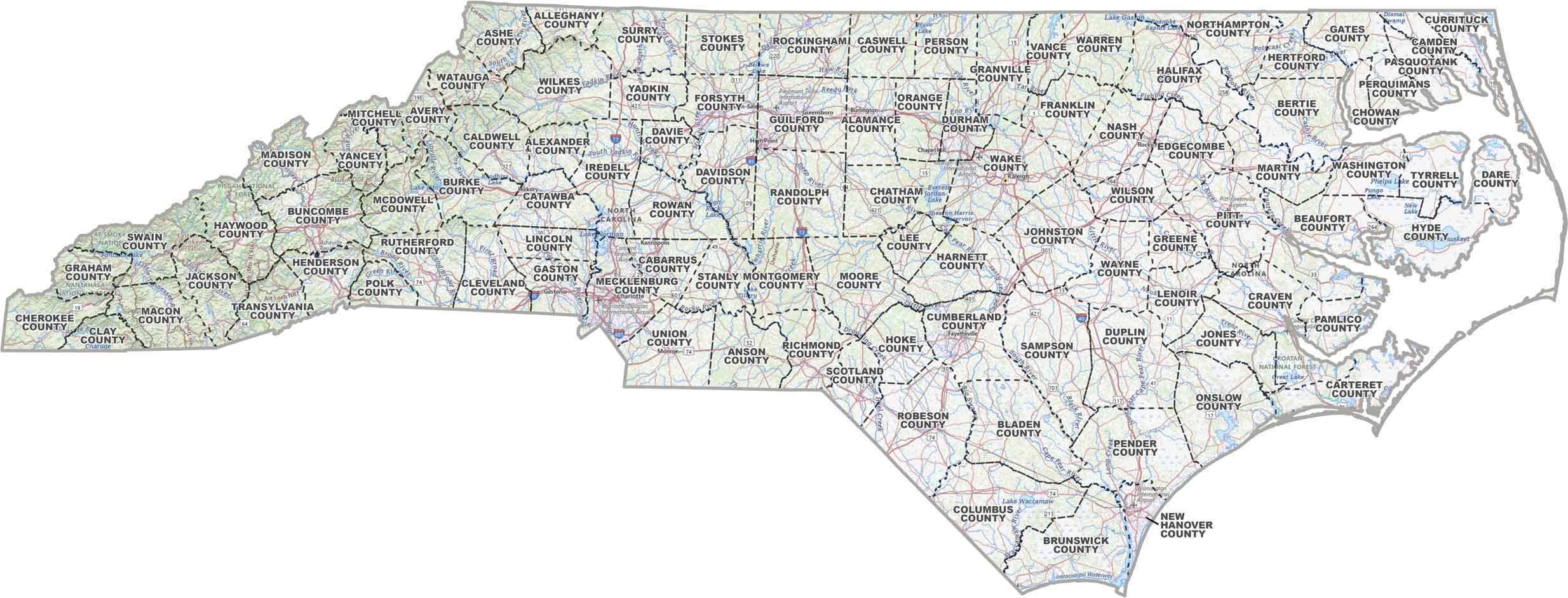
PHYSICAL MAP
North Carolina Topographic County Map
This map gives you a full view of North Carolina. It has county lines, major highways, city names, with rivers and lakes marked.
SATELLITE IMAGERY
North Carolina Satellite County Map
Our satellite map shows all the detail of North Carolina with county names and borders. You’ll see that it’s full of green forests, busy cities, winding rivers, and long stretches of coast.

OUTLINE MAP
North Carolina Simple County Map
This one’s clean and to the point. Just North Carolina divided by county, with easy-to-read labels. See how the state’s laid out.

North Carolina Counties
When it comes to population, Mecklenburg County is the most populous, thanks to Charlotte. It’s the biggest city in the state with banking headquarters and NASCAR ties. It’s like Wall Street meets Daytona. On the other hand, there’s Tyrrell County out on the coast. It’s the least populous, with mostly swamps and forests.
Most Populous: Mecklenburg County
Least Populous: Tyrrell County

When in comes to landmass (excluding water), Robeson County is the largest county in North Carolina. According to the US Census Bureau, it has a land area of 947.3 square miles. As for the smallest county, that would be Chowan County at 172.6 square miles. Our table below breaks it down even more by land and water.
Largest Area: Robeson County
Smallest Area: Chowan County
North Carolina started carving out counties back in 1664, when it was still part of the Carolina colony. They do have some quirky stories behind their names. Take Transylvania County. No, it’s not full of vampires, but it does have some of the best waterfalls in the state. Or how about Dare County? It’s named after Virginia Dare, the first English child born in America.
North Carolina County List
Here’s a table with all 100 counties in North Carolina. See how we break up area by land and water.
| FIPS Code | Name | Land % | Water % | Total Area (sq mi) |
|---|---|---|---|---|
| 37-001 | Alamance County | 97.5 | 2.5 | 434.2 |
| 37-003 | Alexander County | 98.6 | 1.4 | 263.6 |
| 37-005 | Alleghany County | 99.4 | 0.6 | 235.8 |
| 37-007 | Anson County | 99.0 | 1.0 | 537.1 |
| 37-009 | Ashe County | 99.3 | 0.7 | 428.2 |
| 37-011 | Avery County | 99.9 | 0.1 | 247.5 |
| 37-013 | Beaufort County | 86.4 | 13.6 | 962.8 |
| 37-015 | Bertie County | 94.3 | 5.7 | 741.3 |
| 37-017 | Bladen County | 98.6 | 1.4 | 887.6 |
| 37-019 | Brunswick County | 80.9 | 19.1 | 1,049.5 |
| 37-021 | Buncombe County | 99.5 | 0.5 | 659.9 |
| 37-023 | Burke County | 98.4 | 1.6 | 514.2 |
| 37-025 | Cabarrus County | 99.3 | 0.7 | 363.9 |
| 37-027 | Caldwell County | 99.4 | 0.6 | 474.6 |
| 37-029 | Camden County | 77.5 | 22.5 | 310.3 |
| 37-031 | Carteret County | 38.2 | 61.8 | 1,330.4 |
| 37-033 | Caswell County | 99.2 | 0.8 | 428.7 |
| 37-035 | Catawba County | 96.5 | 3.5 | 416.0 |
| 37-037 | Chatham County | 96.2 | 3.8 | 709.0 |
| 37-039 | Cherokee County | 97.6 | 2.4 | 466.7 |
| 37-041 | Chowan County | 73.9 | 26.1 | 233.6 |
| 37-043 | Clay County | 97.4 | 2.6 | 220.8 |
| 37-045 | Cleveland County | 99.2 | 0.8 | 468.1 |
| 37-047 | Columbus County | 98.2 | 1.8 | 955.0 |
| 37-049 | Craven County | 91.4 | 8.6 | 773.3 |
| 37-051 | Cumberland County | 99.1 | 0.9 | 658.5 |
| 37-053 | Currituck County | 49.8 | 50.2 | 526.4 |
| 37-055 | Dare County | 24.9 | 75.1 | 1,541.7 |
| 37-057 | Davidson County | 97.5 | 2.5 | 567.6 |
| 37-059 | Davie County | 98.9 | 1.1 | 266.6 |
| 37-061 | Duplin County | 99.3 | 0.7 | 820.2 |
| 37-063 | Durham County | 96.2 | 3.8 | 297.9 |
| 37-065 | Edgecombe County | 99.7 | 0.3 | 506.9 |
| 37-067 | Forsyth County | 98.9 | 1.1 | 412.3 |
| 37-069 | Franklin County | 99.4 | 0.6 | 494.6 |
| 37-071 | Gaston County | 97.8 | 2.2 | 363.7 |
| 37-073 | Gates County | 98.5 | 1.5 | 345.7 |
| 37-075 | Graham County | 96.8 | 3.2 | 301.6 |
| 37-077 | Granville County | 99.0 | 1.0 | 537.6 |
| 37-079 | Greene County | 99.8 | 0.2 | 267.2 |
| 37-081 | Guilford County | 98.2 | 1.8 | 657.6 |
| 37-083 | Halifax County | 99.1 | 0.9 | 730.3 |
| 37-085 | Harnett County | 98.9 | 1.1 | 601.3 |
| 37-087 | Haywood County | 99.8 | 0.2 | 554.5 |
| 37-089 | Henderson County | 99.4 | 0.6 | 375.1 |
| 37-091 | Hertford County | 98.0 | 2.0 | 360.4 |
| 37-093 | Hoke County | 99.6 | 0.4 | 391.6 |
| 37-095 | Hyde County | 42.0 | 58.0 | 1,459.0 |
| 37-097 | Iredell County | 96.1 | 3.9 | 597.4 |
| 37-099 | Jackson County | 99.2 | 0.8 | 495.0 |
| 37-101 | Johnston County | 99.4 | 0.6 | 795.7 |
| 37-103 | Jones County | 99.5 | 0.5 | 473.7 |
| 37-105 | Lee County | 98.4 | 1.6 | 259.2 |
| 37-107 | Lenoir County | 99.4 | 0.6 | 401.4 |
| 37-109 | Lincoln County | 97.0 | 3.0 | 304.9 |
| 37-111 | McDowell County | 98.8 | 1.2 | 445.3 |
| 37-113 | Macon County | 99.2 | 0.8 | 519.7 |
| 37-115 | Madison County | 99.6 | 0.4 | 451.5 |
| 37-117 | Martin County | 99.9 | 0.1 | 456.7 |
| 37-119 | Mecklenburg County | 95.9 | 4.1 | 546.1 |
| 37-121 | Mitchell County | 99.7 | 0.3 | 221.9 |
| 37-123 | Montgomery County | 98.0 | 2.0 | 501.5 |
| 37-125 | Moore County | 98.9 | 1.1 | 705.7 |
| 37-127 | Nash County | 99.6 | 0.4 | 542.8 |
| 37-129 | New Hanover County | 58.4 | 41.6 | 328.9 |
| 37-131 | Northampton County | 97.5 | 2.5 | 550.5 |
| 37-133 | Onslow County | 84.2 | 15.8 | 905.2 |
| 37-135 | Orange County | 99.1 | 0.9 | 401.0 |
| 37-137 | Pamlico County | 59.9 | 40.1 | 561.6 |
| 37-139 | Pasquotank County | 78.4 | 21.6 | 289.3 |
| 37-141 | Pender County | 93.3 | 6.7 | 934.2 |
| 37-143 | Perquimans County | 75.1 | 24.9 | 328.9 |
| 37-145 | Person County | 97.0 | 3.0 | 404.4 |
| 37-147 | Pitt County | 99.5 | 0.5 | 655.5 |
| 37-149 | Polk County | 99.7 | 0.3 | 238.4 |
| 37-151 | Randolph County | 99.0 | 1.0 | 790.0 |
| 37-153 | Richmond County | 98.7 | 1.3 | 479.7 |
| 37-155 | Robeson County | 99.8 | 0.2 | 949.2 |
| 37-157 | Rockingham County | 98.8 | 1.2 | 572.8 |
| 37-159 | Rowan County | 97.6 | 2.4 | 523.9 |
| 37-161 | Rutherford County | 99.7 | 0.3 | 567.2 |
| 37-163 | Sampson County | 99.8 | 0.2 | 947.6 |
| 37-165 | Scotland County | 99.5 | 0.5 | 320.6 |
| 37-167 | Stanly County | 97.6 | 2.4 | 404.9 |
| 37-169 | Stokes County | 98.5 | 1.5 | 455.8 |
| 37-171 | Surry County | 99.3 | 0.7 | 537.7 |
| 37-173 | Swain County | 97.7 | 2.3 | 540.2 |
| 37-175 | Transylvania County | 99.5 | 0.5 | 380.4 |
| 37-177 | Tyrrell County | 65.4 | 34.6 | 597.2 |
| 37-179 | Union County | 98.9 | 1.1 | 639.6 |
| 37-181 | Vance County | 93.9 | 6.1 | 268.7 |
| 37-183 | Wake County | 97.4 | 2.6 | 857.2 |
| 37-185 | Warren County | 96.6 | 3.4 | 444.3 |
| 37-187 | Washington County | 82.1 | 17.9 | 421.9 |
| 37-189 | Watauga County | 99.7 | 0.3 | 313.3 |
| 37-191 | Wayne County | 99.3 | 0.7 | 557.7 |
| 37-193 | Wilkes County | 99.7 | 0.3 | 757.2 |
| 37-195 | Wilson County | 98.5 | 1.5 | 373.1 |
| 37-197 | Yadkin County | 99.2 | 0.8 | 337.7 |
| 37-199 | Yancey County | 99.8 | 0.2 | 313.2 |
Source: United States Census Bureau
the outline with white interior link is broken, it downloads a map of arizona, not NC
Thanks for letting us know. We fixed it and is now working