Glacier County Map, Montana
Glacier County Map Collection


We allow you to use our Glacier County map. Attribution is required.
Glacier County, Montana

Glacier County is up in the far north of Montana, right where the Rockies and the Great Plains meet. It’s a place of breathtaking beauty. The eastern half of Glacier National Park falls within its borders, which pretty much guarantees some of the most spectacular scenery you’ll ever lay eyes on.
Cut Bank is the county seat and it’s known for being one of the coldest spots in the contiguous U.S. Locals joke that they have two seasons: winter and August. The Blackfeet Indian Reservation covers a big chunk of the county, adding a rich layer of cultural heritage to the mix. Wildlife is everywhere, from grizzlies and mountain goats in the high country to pronghorn antelope on the prairies.
Ranching and farming are still major players here, but tourism is giving them a run for their money. You might spot oil rigs here. It’s a reminder that there’s more to this place than just pretty views. It’s the kind of place where you can drive for hours without seeing another soul, but those you do meet will likely greet you with a wave and a smile.
| Category | Details |
|---|---|
| County Name | Glacier County |
| County Seat | Cut Bank |
| Population | Approximately 14,000 |
| Cities, Towns, and Communities | Cut Bank, Browning, East Glacier Park, Babb, Heart Butte |
| Interstates and Highways | US 2, US 89 |
| FIPS Code | 30-035 |
| Total Area (Land and Water) | 3,037 square miles (Land: 2,995 sq mi, Water: 42 sq mi) |
| Adjacent Counties (and Direction) | Flathead County (West), Pondera County (South), Toole County (East) |
| Time Zone | Mountain Time Zone (MT) |
| State | Montana |
| Coordinates | 48.7310° N, 113.2230° W |
| Etymology | Named after the nearby Glacier National Park |
| Major Landmarks | Glacier National Park, Blackfeet Indian Reservation, Two Medicine Lake |
| Website | Glacier County Website |
PHYSICAL MAP
Glacier County Topographic Map
Glacier County is shaped by fierce natural forces. Deep valleys carve through the mountains, leaving wide, shadowed gaps. The Rocky Mountains hammer into the west side. To the east, the land flattens. Use our zoom tool in the topographic map to explore the county.

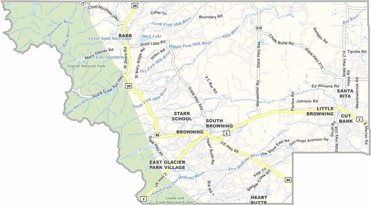
TRANSPORTATION MAP
Glacier County Road Map
Glacier County isn’t packed with roads, but the ones it has are key. U.S. Highway 2 crosses the southern edge. Then, there are smaller roads like Highway 89 and drives north toward Canada. Zoom in on our road map below to follow every curve through the mountains and plains.

SATELLITE IMAGERY
Glacier County Satellite Map
At first glance, Glacier County looks split in two. In the west, rugged mountains cast dark, broken shadows. But east of there, the earth stretches out in soft, muted colors.

OUTLINE MAP
Glacier County Blank Map
The shape of Glacier County leans long and jagged. Its northern edge hugs the Canadian border. Though no river marks a boundary, steep ridges define much of the western side.

Neighboring Counties
Here are the 3 neighboring counties of Glacier County:


Montana County Map

Big skies, bigger adventures. Montana’s 56 counties are pure wild wonder. Yellowstone, Glacier and Grand Teton. Big Sky Country knows how to show off.