Jefferson Parish Map, Louisiana

Jefferson Parish Map Collection


We allow you to use our Jefferson Parish map. Attribution is required.
Jefferson Parish, Louisiana

Jefferson Parish hugs the Mississippi River just west of New Orleans. It stretches from Lake Pontchartrain down to the Gulf of Mexico.
It’s a mix of suburban sprawl and bayou country. Metairie is the largest city and it’s where most folks live and work. You’ll find great Creole and Cajun food here. Think gumbo, jambalaya, and crawfish étouffée.
The parish has seen its share of hurricanes, but people here are resilient. On weekends, locals often go to the Lakefront for fishing or just to catch a breeze.
| Category | Details |
|---|---|
| Parish Name | Jefferson Parish |
| Parish Seat | Gretna |
| Population | Approximately 435,000 |
| Cities, Towns, and Communities | Metairie, Kenner, Gretna, Westwego, Harahan, Jefferson, Marrero, River Ridge, Avondale, Lafitte, Grand Isle |
| Interstates and Highways | I-10, I-310, I-610, US-61, US-90, LA-23, LA-45 |
| FIPS Code | 22-051 |
| Total Area (Land and Water) | 665 square miles (296 sq mi land, 369 sq mi water) |
| Adjacent Parishes (and Direction) | Orleans Parish (East), St. Bernard Parish (East), Plaquemines Parish (East), Lafourche Parish (West), St. Charles Parish (West), St. Tammany Parish (North) |
| Time Zone | Central Time Zone (CT) |
| State | Louisiana |
| Coordinates | 29.6499° N, 90.1121° W |
| Etymology | Named after Thomas Jefferson, the third President of the United States |
| Major Landmarks | Jean Lafitte National Historical Park and Preserve, Lafreniere Park, The National WWII Museum, Bayou Segnette State Park, Grand Isle State Park |
| Website | Jefferson Parish Website |
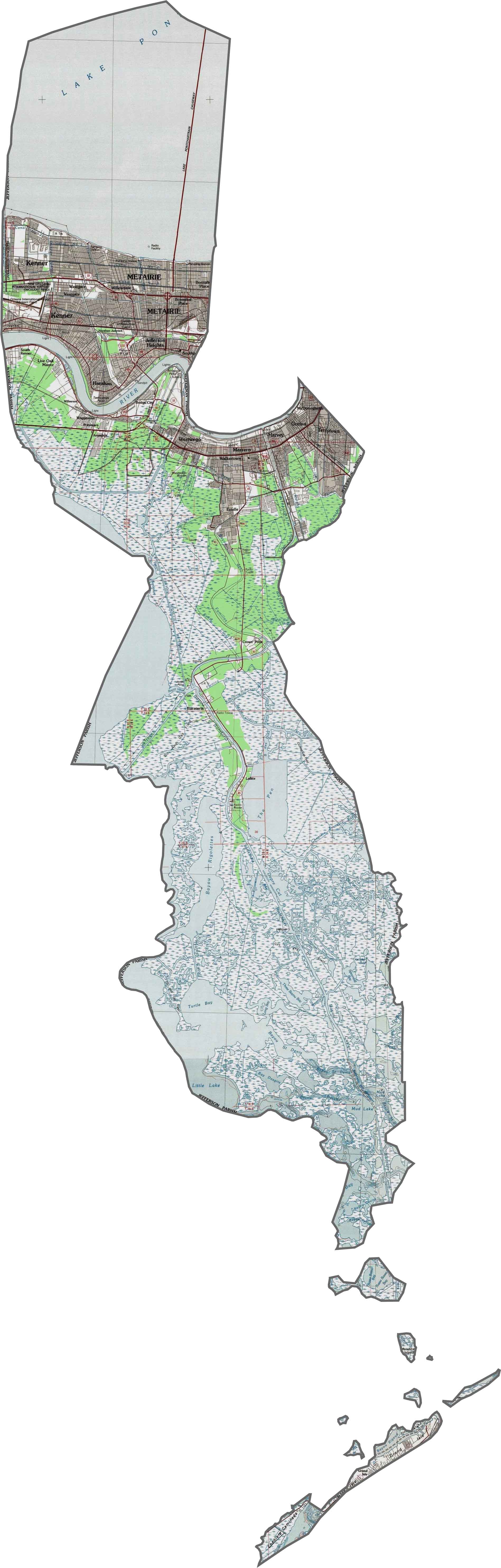
PHYSICAL MAP
Jefferson Parish Topographic Map
Jefferson Parish thrives on its highway connections. I-10 cuts across the north while the elevated I-610 provides a crucial bypass. The iconic Causeway Boulevard (LA 3046) leads to Lake Pontchartrain. Zoom in to see all the routes crossing this busy parish.
SATELLITE IMAGERY
Jefferson Parish Satellite Map
A mix of dense suburbia and sprawling wetlands defines Jefferson. Neighborhoods grid the north near New Orleans, while marshes dominate the south.

OUTLINE MAP
Jefferson Parish Blank Map
Jefferson County is very long in the north-south direction. It wraps around New Orleans in the north. Lake Pontchartrain forms much of its northern border.

Neighboring Parishes
Here are the 6 neighboring parishes of Jefferson Parish:


Louisiana Parish Map

In Louisiana, you’ll taste it in the hot sauce and hear it in the midnight blues. Laissez les bon temps rouler? Try one of our Louisiana parish maps to explore. Come for the beignets. Stay for the bayou.