Nassau County Map, New York

Nassau County Map Collection

We allow you to use our Nassau County map. Attribution is required.
Nassau County, New York

Long Island’s western half is home to Nassau County. It’s a mix of suburban area and coastal beauty. It’s where New York City’s hustle meets laid-back beach vibes.
The county has more than 60 miles of coastline, including the famous Jones Beach. And you can’t talk about Nassau without mentioning the Gold Coast mansions that inspired “The Great Gatsby”.
Hofstra University is a private university in Hempstead. The Nassau Coliseum has hosted everything from rock concerts to NHL Islanders games. There’s also the Old Bethpage Village Restoration, a living museum of 19th-century life.
| Category | Details |
|---|---|
| County Name | Nassau County |
| County Seat | Mineola |
| Population | Approximately 1,400,000 |
| Cities, Towns, and Communities | Hempstead, Long Beach, Glen Cove, Westbury, Garden City |
| Interstates and Highways | Interstate 495 (Long Island Expressway), Interstate 295, U.S. Route 1, New York State Route 27 |
| FIPS Code | 36-059 |
| Total Area (Land and Water) | 287 square miles (284 sq mi land, 3 sq mi water) |
| Adjacent Counties (and Direction) | Fairfield County, Connecticut (North), Queens County (West), Suffolk County (East), Westchester County (Northwest), Bronx County (Northwest) |
| Time Zone | Eastern Time Zone (ET) |
| State | New York |
| Coordinates | 40.7380° N, 73.6376° W |
| Etymology | Named after Nassau, the Dutch family of King William III of England |
| Major Landmarks | Jones Beach State Park, Roosevelt Field, Nassau Veterans Memorial Coliseum |
| Website | Nassau County Website |
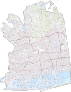
TRANSPORTATION MAP
Nassau County Road Map
Fast-moving parkways cross this compact county. The Long Island Expressway (I-495) cuts straight through, east to west. But the Northern State Parkway offers a quieter, tree-lined route. Though traffic can be rough, access is solid. If you’re curious about more detailed route information, our zoom tool below will get you there.

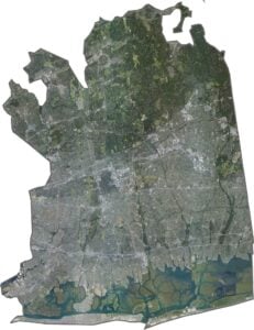
SATELLITE IMAGERY
Nassau County Satellite Map
From space, Nassau County is dense but organized. Subdivisions fill most of the land. Highways slice clean lines through the grid. The North Shore shows more tree cover, while the South Shore has more marinas and beach access.

OUTLINE MAP
Nassau County Blank Map
Nassau County borders Queens County (part of NYC) to the west. The northern edge meets Long Island Sound, though the shoreline is jagged with bays. Suffolk is located to the east. Despite its size, the coastline adds some curves to an otherwise boxy outline.

Neighboring Counties
Here are the 5 neighboring counties of Nassau County:


New York County Map

New York has 62 counties. Each with their own attitude. Manhattan’s chaos to the Adirondacks’ silence… and how about those Buffalo wings? Explore our NY counties maps.