Ellis County Map, Texas

Ellis County Map Collection


We allow you to use our Ellis County map. Attribution is required.
Ellis County, Texas

Ellis County is just south of Dallas. This county offers a taste of small-town Texas with a side of big city convenience. Waxahachie is the county seat and is known for its stunning courthouse. It’s a film location favorite.
The whole county bursts with color each spring. Bluebonnets carpet the fields. It’s a sight to see. Agriculture is still big here. Cotton was once king but now it’s a mix of crops and cattle.
The county’s growing fast with new neighborhoods springing up. But there’s still plenty of open space. Old-timers and newcomers mix and mingle. It’s a place in transition, holding onto its roots while embracing change.
| Category | Details |
|---|---|
| County Name | Ellis County |
| County Seat | Waxahachie |
| Population | Approximately 220,000 |
| Cities, Towns, and Communities | Waxahachie, Ennis, Midlothian, Red Oak, Ferris, Italy, Palmer |
| Interstates and Highways | Interstate 35E, Interstate 45, U.S. Highway 67, U.S. Highway 77, State Highway 287 |
| FIPS Code | 48-139 |
| Total Area (Land and Water) | 952 square miles (936 sq mi land, 16 sq mi water) |
| Adjacent Counties (and Direction) | Dallas County (North), Kaufman County (Northeast), Henderson County (East), Navarro County (South), Hill County (Southwest), Johnson County (West), Tarrant County (Northwest) |
| Time Zone | Central Time Zone (CST) |
| State | Texas |
| Coordinates | 32°22’N, 96°47’W |
| Etymology | Named after Richard Ellis, president of the convention that produced the Texas Declaration of Independence |
| Major Landmarks | Scarborough Renaissance Festival, Ellis County Courthouse, Texas Motorplex |
| Website | Ellis County Website |
PHYSICAL MAP
Ellis County Topographic Map
The land here rolls gently. One defining feature is the Waxahachie Creek basin, which carves a shallow path through the center. Elevation climbs ever so slightly in the west. It’s not flat, but the changes are smooth.

TRANSPORTATION MAP
Ellis County Road Map
Ellis County’s roads do a bit of everything. They funnel traffic toward Dallas, loop around growing suburbs, and stretch across fields. The main highways are I-35E, I-45, and U.S. Highway 67. Use our zoom tool to explore every intersection.

SATELLITE IMAGERY
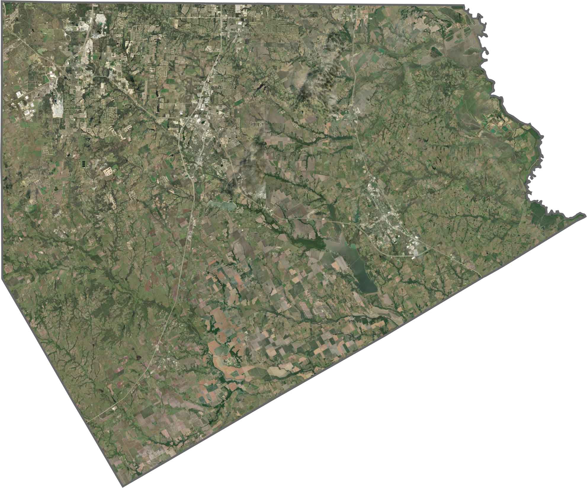
Ellis County Satellite Map
The mix of land use in Ellis County is easy to spot from above. Pockets of development huddle near highways, while fields and pastures stretch out in every direction. Bardwell Lake is the largest reservoir in the county.
OUTLINE MAP
Ellis County Blank Map
Ellis County has a somewhat triangular shape. The Trinity River forms the eastern border. It doesn’t border another state, but it hugs the southern edge of the Dallas area.

Neighboring Counties
Here are the 7 neighboring counties of Ellis County:


Texas County Map

254 legendary Texas county maps. From the Panhandle to the Rio Grande, we’ve got the Lone Star State mapped. That means more rodeos, honky-tonk, and Texas BBQ.