St. Louis Independent City Map, Missouri

St. Louis City Map Collection
We allow you to use our St. Louis Independent City map. Attribution is required.
St. Louis Independent City, Missouri

St. Louis Independent City is a unique urban area that stands separate from any county. From the iconic Gateway Arch to Forest Park’s sprawling green space, it’s a sightseeing behemoth.
You’ll find the Mississippi River running along its eastern edge, marking a border from Illinois. Popular spots like the Delmar Loop and Soulard Market jump off the map.
It’s perfect for day trips and sightseeing. Are you a sports fan? If so, catch a game at Busch Stadium or head to the Enterprise Center for some hockey action.
| Category | Details |
|---|---|
| County Name | St. Louis Independent City |
| Population | Approximately 288,000 |
| Cities, Towns, and Communities | St. Louis (Independent city) |
| Interstates and Highways | I-44, I-55, I-64, I-70, U.S. Route 40, U.S. Route 61, Missouri Route 100 |
| FIPS Code | 29-510 |
| Total Area (Land and Water) | 66 square miles (land: 61 sq mi, water: 5 sq mi) |
| Adjacent Counties (and Direction) | St. Louis County (West), Madison County, Illinois (Northeast), St. Clair County, Illinois (Southeast) |
| Time Zone | Central Time Zone (CT) |
| State | Missouri |
| Coordinates | 38.6270° N, 90.1994° W |
| Etymology | Named after King Louis IX of France |
| Major Landmarks | Gateway Arch, Forest Park, Busch Stadium, Enterprise Center, St. Louis Zoo, City Museum |
| Website | St. Louis Independent City Website |
TRANSPORTATION MAP
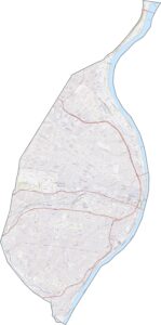
St. Louis City Road Map
St. Louis City is the busiest city in all of Missouri. I-70 slices across the north, feeding right into downtown. I-44 and I-64 also roars through the center. Zoom in with our road map below to pick your path through the heart of the city.

SATELLITE IMAGERY
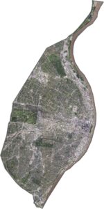
St. Louis City Satellite Map
From above, St. Louis looks like concrete, buildings, and green. Downtown pops out first. It’s tough to see, but the Gateway Arch shines right along the river. Parks like Forest Park and Tower Grove punch big green holes in the landscape too.

OUTLINE MAP
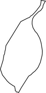
St. Louis City Blank Map
St. Louis City is boxed in tight and it knows it. The Mississippi River locks it down on the east side, curving like a giant wall. Although it borders St. Louis County everywhere else, the city is its own beast. It’s shaped like a misshapen wedge, pointing eastward toward Illinois.

Neighboring Counties
Here are the 3 neighboring counties of St. Louis City:


Missouri County Map

Explore the Show-Me State. We have all 114 county maps as your guide to smoky BBQ, Ozark trails, and sunsets over the mighty Mississippi. From St. Louis to Branson, Missouri has something on every road.