Boone County Map, Kentucky

Boone County Map Collection

We allow you to use our Boone County map. Attribution is required.
Boone County, Kentucky

Boone County is in northern Kentucky, right across the Ohio River from Cincinnati. It’s one of the fastest-growing counties in the state, with about 130,000 people.
Burlington is the county seat, but Florence is the largest city. Cincinnati/Northern Kentucky International Airport is here, so the skies are always busy. If you’re into horse racing, Turfway Park has live races.
Big Bone Lick State Park is here and worth a visit. They’ve got some mammoth bones on display. The county’s part of the Cincinnati metro area, so there’s plenty to do. The county is named after Daniel Boone, of course.
| Category | Details |
|---|---|
| County Name | Boone County |
| County Seat | Burlington |
| Population | Approximately 150,000 |
| Cities, Towns, and Communities | Florence, Union, Walton, Hebron, Burlington |
| Interstates and Highways | I-75, I-71, I-275, US-42, US-127 |
| FIPS Code | 21-015 |
| Total Area (Land and Water) | 256 sq mi (Land: 246 sq mi; Water: 10 sq mi) |
| Adjacent Counties (and Direction) | Hamilton County, Ohio (North), Kenton County (East), Grant County (South), Gallatin County (Southwest), Switzerland County, Indiana (West), Ohio County, Indiana (West), Dearborn County, Indiana (Northwest) |
| Time Zone | Eastern Time Zone (ET) |
| State | Kentucky |
| Coordinates | 38.9941° N, 84.7316° W |
| Etymology | Named after Daniel Boone, a famous American pioneer and explorer |
| Major Landmarks | Creation Museum, Big Bone Lick State Park, Florence Speedway |
| Website | Boone County Website |
TRANSPORTATION MAP
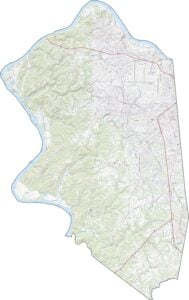
Boone County Road Map
Boone County’s roads go through everything from suburbs to quiet farmland. Although many county roads are narrow and winding, major highways like I-75 and I-71 provide fast connections to Cincinnati (to the northeast). Try and explore every route in detail using our interactive zoom tool below.

SATELLITE IMAGERY
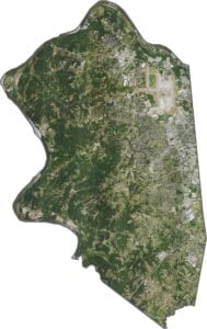
Boone County Satellite Map
From above, Boone County is mostly green fields and subdivisions. The Cincinnati/Northern Kentucky International Airport stands out sharply, while the Ohio River curves along the northern edge. Though development is dense near Florence, farmland break up the urban areas.

OUTLINE MAP
Boone County Blank Map
Boone County’s outline is uneven, stretching westward like a bent arm. The Ohio River forms its entire northern border, separating it from Ohio. To the south, it touches Grant and Gallatin Counties, while its western edge meets Indiana’s state line.

Neighboring Counties
Here are the 7 neighboring counties of Boone County:


Kentucky County Map

Kentucky isn’t just bluegrass and bourbon. It’s a land where the trees grow tall and the stories grow taller. Find your path with one of our Kentucky county maps.