Daviess County Map, Kentucky

Daviess County Map Collection


We allow you to use our Daviess County map. Attribution is required.
Daviess County, Kentucky

Daviess County is located in northwestern Kentucky. It’s home to Owensboro, the state’s fourth-largest city. The Ohio River forms its northern border.
The county sits next to Indiana with U.S. Route 60 and the Audubon Parkway. With a population of around 100,000, it’s mostly a mix of urban and rural landscapes.
If you’re into music, you’ll appreciate the county’s bluegrass roots, celebrated at the Bluegrass Music Hall of Fame and Museum. The county is also home to the Owensboro Museum of Science and History.
| Category | Details |
|---|---|
| County Name | Daviess County |
| County Seat | Owensboro |
| Population | Approximately 104,000 |
| Cities, Towns, and Communities | Owensboro, Whitesville, Maceo, Knottsville, West Louisville |
| Interstates and Highways | US-60, US-231, KY-54, I-165 |
| FIPS Code | 21-059 |
| Total Area (Land and Water) | 477 sq mi (Land: 462 sq mi; Water: 15 sq mi) |
| Adjacent Counties (and Direction) | Warrick County, Indiana (Northwest), Spencer County, Indiana (Northeast), Hancock County (East), Ohio County (Southeast), McLean County (Southwest), Henderson County (West) |
| Time Zone | Central Time Zone (CT) |
| State | Kentucky |
| Coordinates | 37.7452° N, 87.1125° W |
| Etymology | Named after Colonel Joseph Hamilton Daveiss, who was killed at the Battle of Tippecanoe |
| Major Landmarks | Smothers Park, Western Kentucky Botanical Garden, Owensboro Museum of Fine Art |
| Website | Daviess County Website |
TRANSPORTATION MAP
Daviess County Road Map
Daviess County’s roads range from wide, modern highways to narrow backroads. While US 60 cuts straight through Owensboro, smaller routes twist through rural hills. Check out our zoom tool to trace every route yourself.

SATELLITE IMAGERY
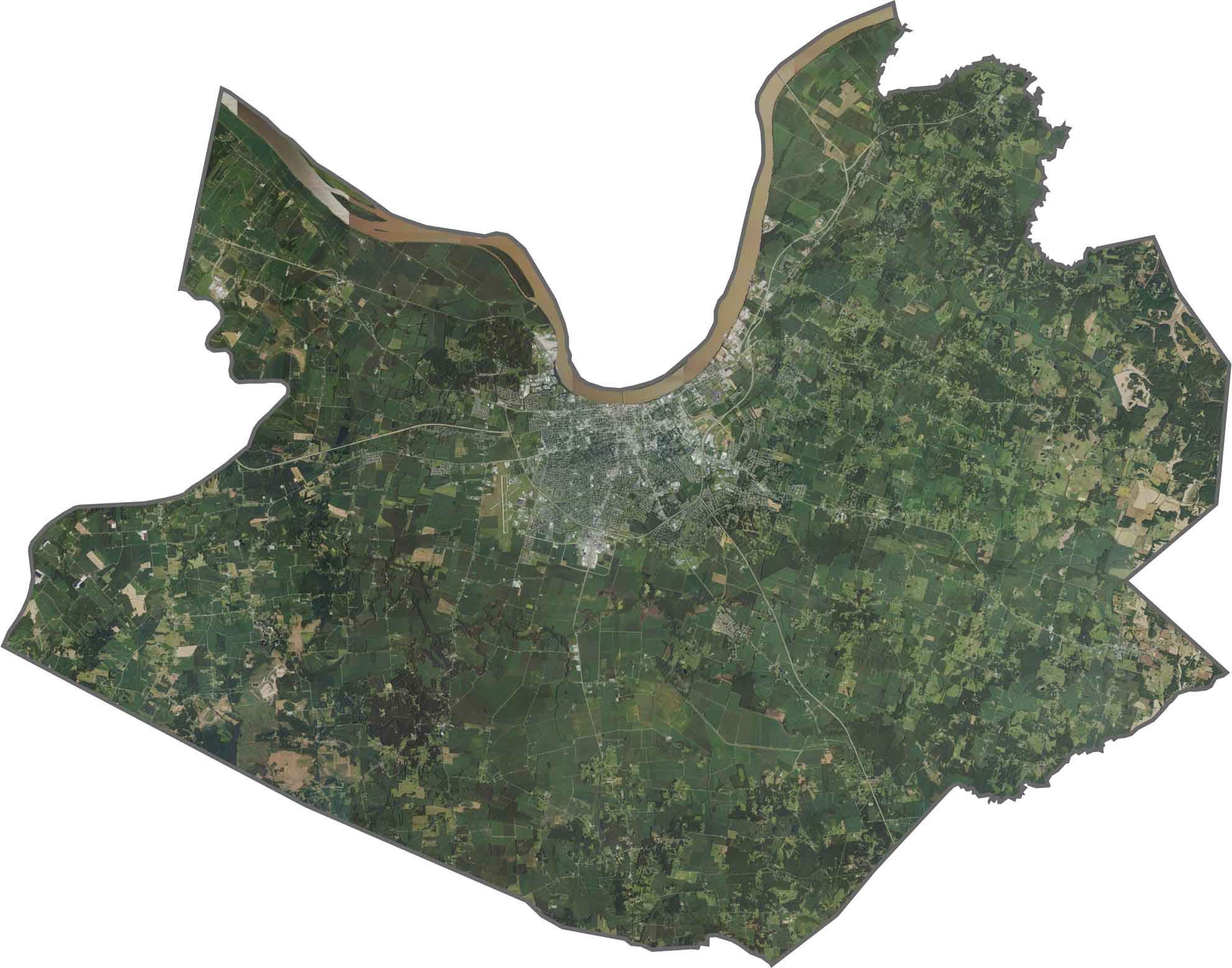
Daviess County Satellite Map
The Ohio River occupies the northern edge, with Owensboro’s clustered buildings hugging its banks. Elsewhere, the land is a mix of croplands and forest, broken up by winding creeks. Though the city appears densely packed, open fields quickly take over beyond the suburbs.
OUTLINE MAP
Daviess County Blank Map
Daviess County is irregular in shape and dips along the Ohio River. That river marks its northern border, with Indiana just across the water. It’s landlocked on other sides, neighboring Hancock, McLean, and Ohio Counties.

Neighboring Counties
Here are the 6 neighboring counties of Daviess County:


Kentucky County Map

Kentucky isn’t just bluegrass and bourbon. It’s a land where the trees grow tall and the stories grow taller. Find your path with one of our Kentucky county maps.