Skagway Municipality Map, Alaska

Skagway Municipality Map Collection


We allow you to use our Skagway Municipality map. Attribution is required.
Skagway Municipality, Alaska

Skagway Municipality is a small area in Southeast Alaska. It’s famous for its role in the Klondike Gold Rush. Only about 1,000 people live here year-round. In summer, the population swells with tourists and seasonal workers.
The town of Skagway is the main settlement. It looks a lot like it did in the 1890s, with old wooden buildings. Tourism is now the biggest industry. Many cruise ships stop here. The White Pass and Yukon Route railroad is a popular attraction.
Skagway is surrounded by steep mountains and fjords. The borough is only 434 square miles, making it one of the smallest in Alaska. You can drive to Skagway from Canada, unusual for Southeast Alaska. Despite its small size, Skagway has a busy summer season with lots going on. The area has hiking trails and beautiful scenery. Winters are quiet, with many businesses closed.
| Category | Details |
|---|---|
| Municipality Name | Skagway Municipality |
| Municipality Seat | Skagway |
| Population | Approximately 1,000 |
| Cities, Towns, and Communities | Skagway |
| Interstates and Highways | None (No interstates; Klondike Highway connects Skagway to the Alaska Highway in Canada) |
| FIPS Code | 02-230 |
| Total Area (Land and Water) | 434 square miles (Land: 422 sq mi, Water: 12 sq mi) |
| Adjacent Boroughs and Census Areas (and Direction) | Haines Borough (West), Juneau City and Borough (South) |
| Time Zone | Alaska Time Zone (AKT) |
| State | Alaska |
| Coordinates | 59.4583° N, 135.3136° W |
| Etymology | Named after the Tlingit word “Shgagwéi,” meaning “a windy place with white caps on the water” |
| Major Landmarks | Klondike Gold Rush National Historical Park, White Pass and Yukon Route Railway, Chilkoot Trail, Skagway Historic District, Dyea |
| Website | Skagway Municipality Website |
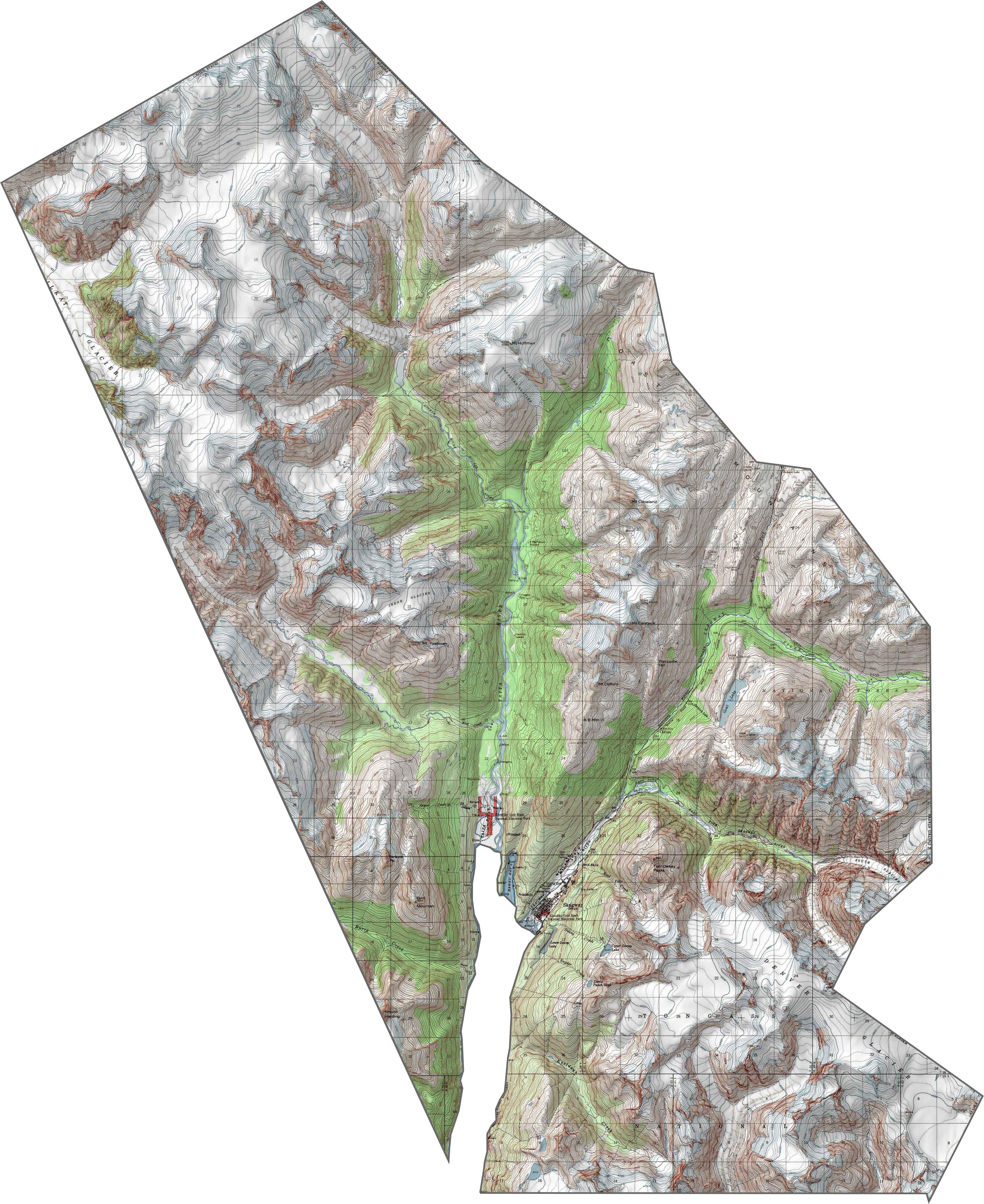
PHYSICAL MAP
Skagway Municipality Topographic Map
Look at how this topo map captures Skagway’s mountain valley setting. The elevation lines show the steep walls that funnel down to the historic town and harbor below.
SATELLITE IMAGERY
Skagway Municipality Satellite Map
Check out this satellite view of historic Skagway, famous from the gold rush days. It’s a tiny developed area surrounded by steep mountain valleys.

OUTLINE MAP
Skagway Municipality Blank Map
This blank map frames tiny Skagway Municipality with its narrow, elongated shape following the historic valley corridor. You can see why this small area became such an important gateway during the gold rush.

Neighboring Boroughs and Census Areas
Here are the 2 neighbors of Skagway Municipality:


Alaska Borough Map

Discover Alaska’s boroughs and census areas with this detailed map. It captures the vast wilderness, rugged coastlines, and remote communities that define the state. Our Alaska Borough Map allows you to see the Last Frontier’s landscapes and hidden corners.