Broome County Map, New York

Broome County Map Collection
We allow you to use our Broome County map. Attribution is required.
Broome County, New York

Broome County is the the heart of the Triple Cities. It’s sitting pretty in New York’s Southern Tier. Binghamton, Johnson City, and Endicott make up this trio. It’s a place with a rich industrial past and a promising future.
The Susquehanna River winds through the county, shaping its landscape and history. Binghamton University brings a youthful energy to the area, with students from all over the world. Spiedies are the local delicacy. If you haven’t tried these marinated meat sandwiches, you’re missing out.
The county has an arts scene, from colorful murals to the philharmonic orchestra. Visitors love the hiking trails its state forests. Despite challenges, Broome County keeps reinventing itself, proving there’s more to New York than just the Big Apple.
| Category | Details |
|---|---|
| County Name | Broome County |
| County Seat | Binghamton |
| Population | Approximately 190,000 |
| Cities, Towns, and Communities | Binghamton, Endicott, Johnson City, Vestal, Windsor, Whitney Point |
| Interstates and Highways | Interstate 81, Interstate 88, U.S. Route 11, New York State Route 17 |
| FIPS Code | 36-007 |
| Total Area (Land and Water) | 715 square miles (706 sq mi land, 9 sq mi water) |
| Adjacent Counties (and Direction) | Chenango County (Northeast), Delaware County (East), Wayne County, Pennsylvania (Southeast), Susquehanna County, Pennsylvania (South), Tioga County (West), Cortland County (Northwest) |
| Time Zone | Eastern Time Zone (ET) |
| State | New York |
| Coordinates | 42.0987° N, 75.9180° W |
| Etymology | Named after John Broome, the fourth Lieutenant Governor of New York |
| Major Landmarks | Binghamton University, Roberson Museum and Science Center, Ross Park Zoo |
| Website | Broome County Website |
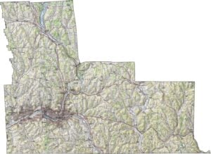
PHYSICAL MAP
Broome County Topographic Map
Broome is a county of river valleys and ridges. The Susquehanna River flows through the center. Rolling hills rise on either side. Though not steep, the terrain can be rugged in places. Broad valleys hold towns and farms. Upland forests cover much of the rest.

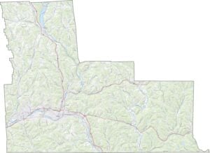
TRANSPORTATION MAP
Broome County Road Map
Broome County is where I-81 and I-88 meet. Though it’s not a huge county, the roads link Binghamton to the rest of the state. Despite its hills, the roads reach far. You can explore them better with our zoom tool.

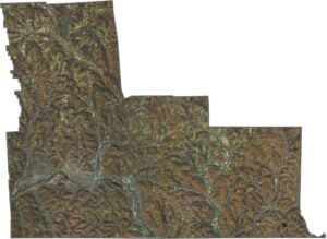
SATELLITE IMAGERY
Broome County Satellite Map
The Susquehanna creates a wide, green path through the county. Binghamton’s layout shows up clearly in the center. Around it, you’ll see a mix of fields and wooded hills. But toward the edges, the hills dominate. Even with cities, the natural landscape is everywhere.

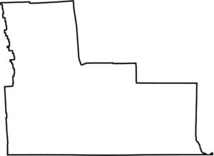
OUTLINE MAP
Broome County Blank Map
Broome County looks a bit like step ladder with 3 rungs. Its southern edge borders Pennsylvania. Most boundaries follow survey lines, not rivers.

Neighboring Counties
Here are the 6 neighboring counties of Broome County:


New York County Map

New York has 62 counties. Each with their own attitude. Manhattan’s chaos to the Adirondacks’ silence… and how about those Buffalo wings? Explore our NY counties maps.