Prince George’s County Map, Maryland

Prince George’s County Map Collection


We allow you to use our Prince George’s County map. Attribution is required.
Prince George’s County, Maryland

East of Washington, D.C., lies Prince George’s County, Maryland. It’s home to the University of Maryland, a major hub for education and innovation.
Sports fans go to FedEx Field to catch a Washington Commanders game. The county is rich in parks and green spaces, with the Anacostia River running through it.
It’s well-connected, with multiple Metro stations making travel to the capital a breeze. Let’s not forget National Harbor for shopping, dining, and waterfront views.
| Category | Details |
|---|---|
| County Name | Prince George’s County |
| County Seat | Upper Marlboro |
| Population | 980,000 |
| Cities, Towns, and Communities | Bowie, College Park, Greenbelt, Laurel, Oxon Hill, Hyattsville, District Heights, and several other communities |
| Interstates and Highways | Interstate 95, Interstate 495 (Capital Beltway), Maryland Route 50, Maryland Route 214 |
| FIPS Code | 24-033 |
| Total Area (Land and Water) | 485.0 square miles (land: 476.0 sq mi, water: 9.0 sq mi) |
| Adjacent Counties (and Direction) | Anne Arundel County (East), Calvert County (Southeast), Charles County (South), Howard County (North), Montgomery County (Northwest), Fairfax County, Virginia (Southwest), Alexandria, Virginia (Southwest), Washington, D.C. (West) |
| Time Zone | Eastern Time Zone (EST) |
| State | Maryland |
| Coordinates | 38.77°N, 76.87°W |
| Etymology | Named after Prince George of Denmark, the husband of Queen Anne of England. |
| Major Landmarks | National Harbor, Six Flags America, Prince George’s Community College, Bladensburg Waterfront Park, FedExField |
| Website | Prince George’s County Website |
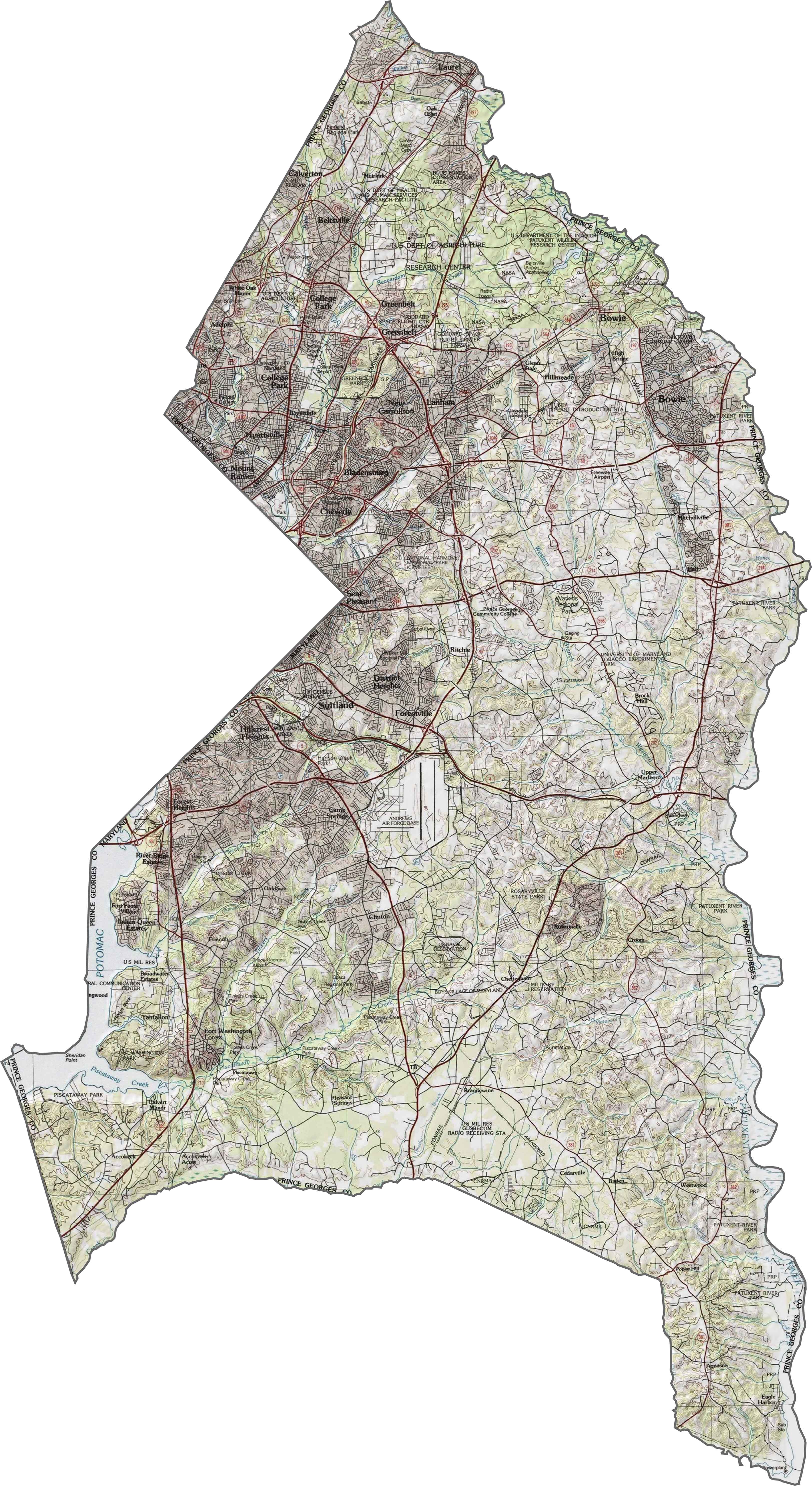
PHYSICAL MAP
Prince George’s County Topographic Map
Prince George is mostly flat coastal plain with gradual elevation changes toward the west. The Patuxent River forms a natural valley along the eastern border. Urban development dominates the west near Washington DC, transitioning to agricultural land otherwise.
TRANSPORTATION MAP
Prince George’s County Road Map
Our road map below shows the major highways and roads that run through Prince George’s County. An interesting feature is the dual-span Wilson Bridge crossing into Virginia. The county has Maryland’s highest concentration of Metro stations outside D.C.

SATELLITE IMAGERY
Prince George’s County Satellite Map
Our Prince George’s County satellite map shows development patterns along major highways. The Joint Base Andrews runway definitely stands out the most. You’ll also notice large swaths of protected parkland that follow the Anacostia and Patuxent river corridors.

OUTLINE MAP
Prince George’s County Blank Map
Prince George’s County borders Washington D.C. to the west. The Patuxent River creates a natural eastern boundary, while Washington DC forms its western boundary.

Neighboring Counties
Here are the 8 neighboring counties of Prince George’s County:


Maryland County Map

With 23 counties and Baltimore City, Maryland gives you a distinct experience in every corner. City life, small towns, and outdoor adventures all come together. Learn more in our Maryland county maps.