Michigan County Map

Michigan County Map Collection

We allow you to use our Michigan County map. Attribution is required.
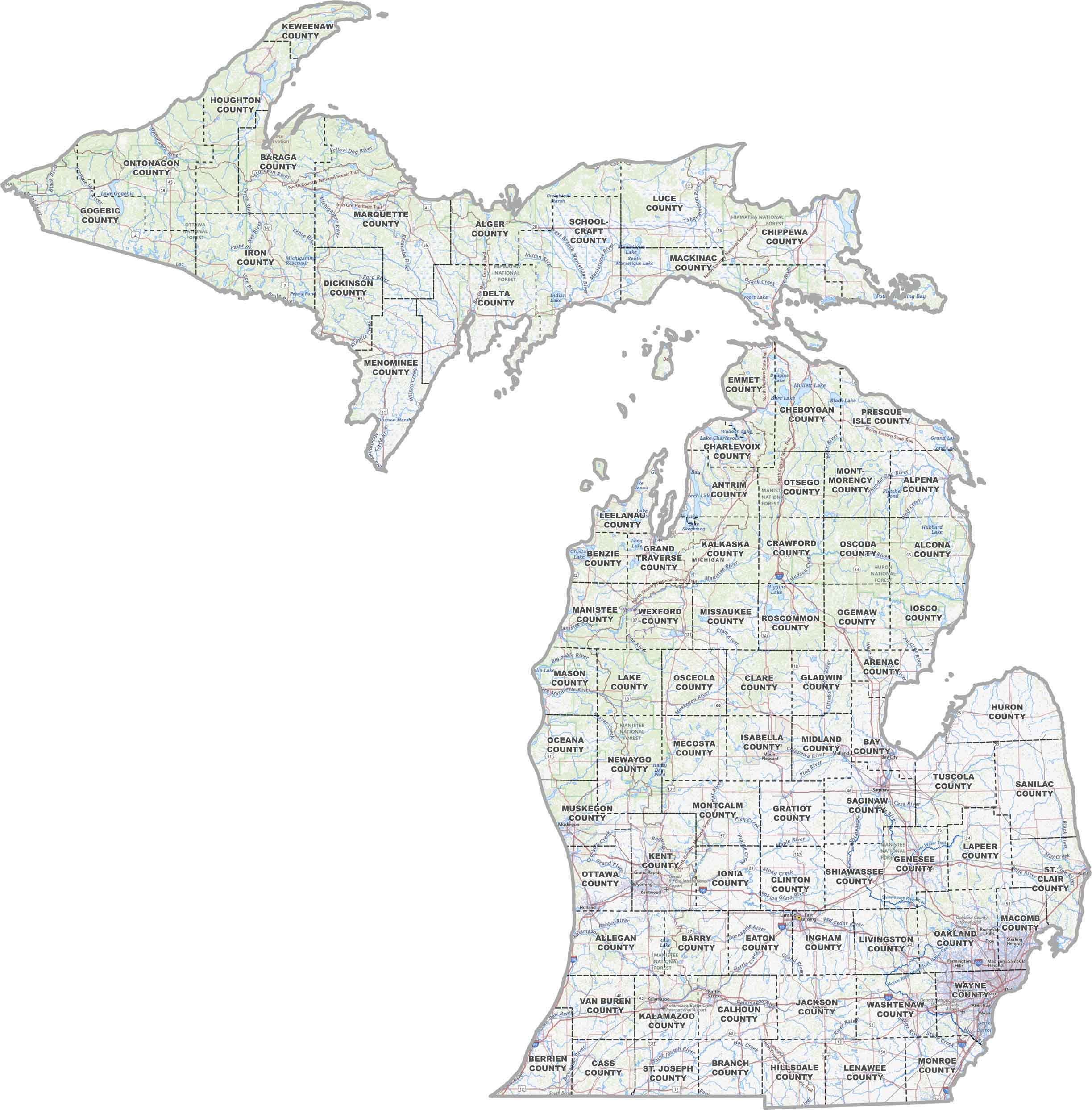
Michigan County Maps
Click on any of our maps of Michigan’s 83 counties.


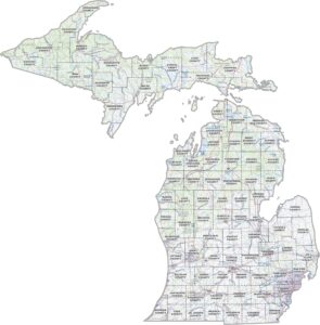
PHYSICAL MAP
Michigan Topographic County Map
Our map of Michigan lays it out clearly with county lines, major roads, lakes, rivers, and key spots. So if you’re heading toward Detroit, our map makes it easy to find Wayne County.
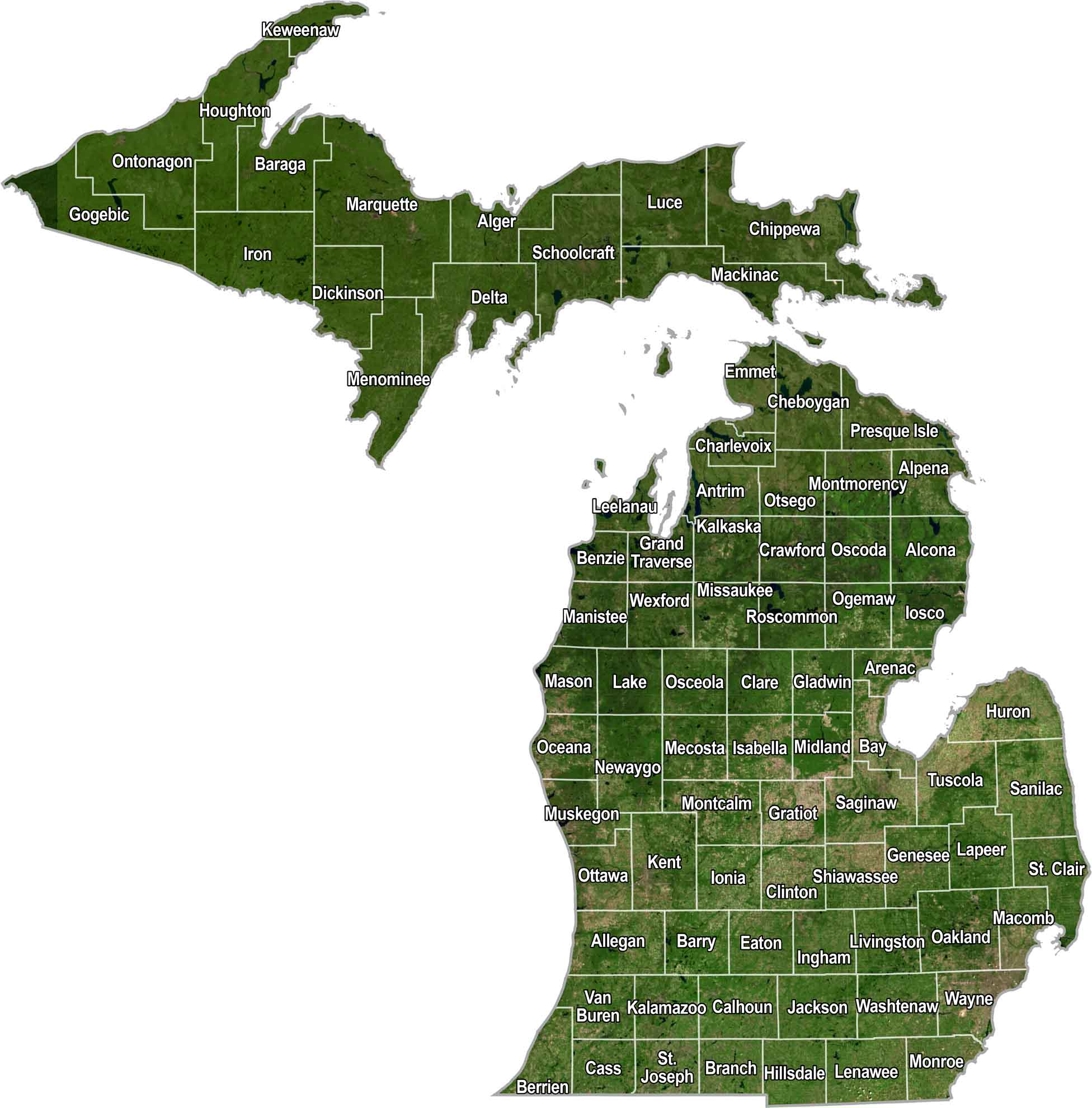
SATELLITE IMAGERY
Michigan Satellite County Map
Michigan’s all about water and woods with cities scattered in between. Our satellite map shows the state’s natural look, plus we’ve added county borders so you can see how it’s all split up.
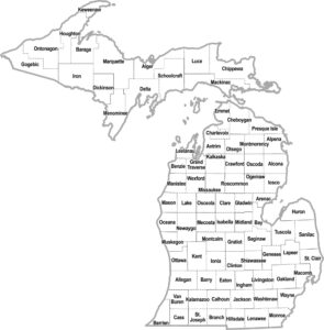
OUTLINE MAP
Michigan Simple County Map
Here’s a plain and simple map of Michigan, broken down by county. It’s perfect for printing because it’s in black and white.
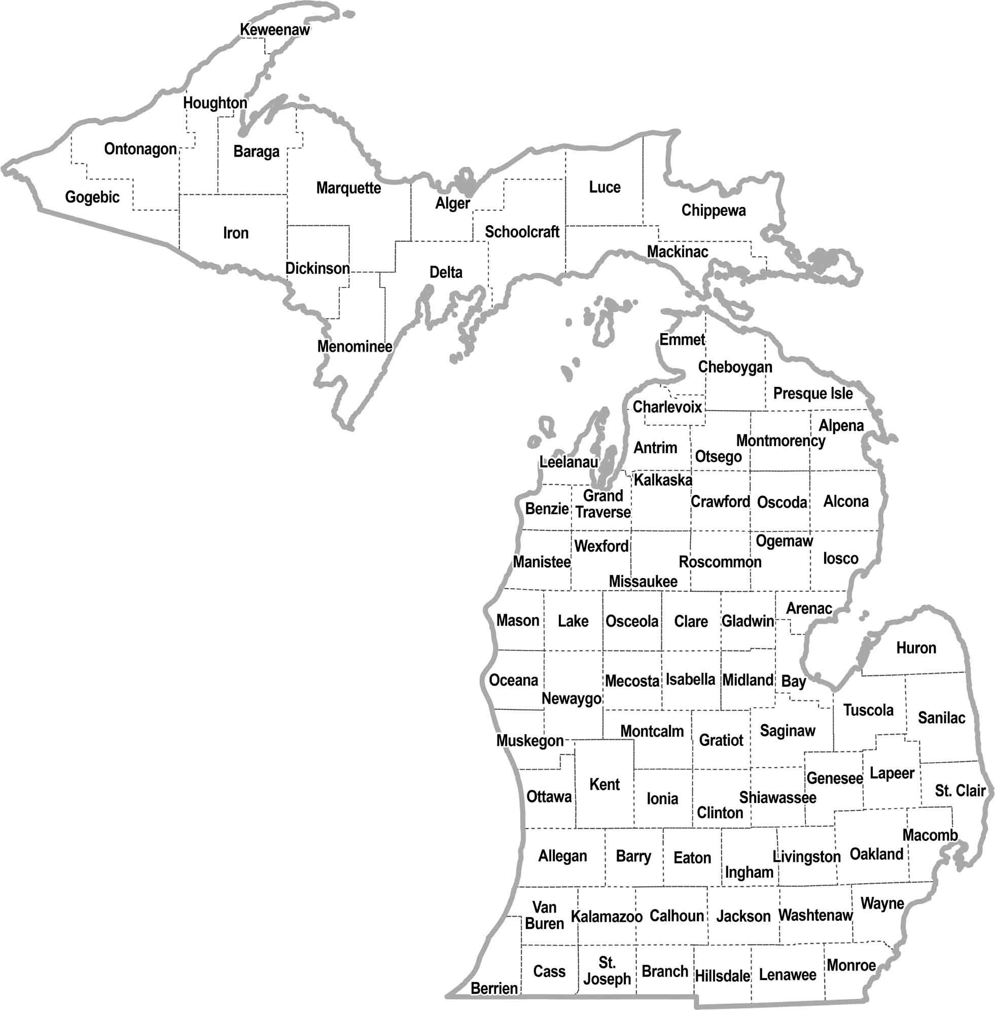
Michigan Counties
The geography of Michigan is pretty cool. You’ve got two peninsulas surrounded by four of the five Great Lakes. One shaped like a mitten. There’s everything from sandy beaches to dense forests, and even some small mountains up north.
Wayne County is where most of the action is. It’s the most populous county, and that’s mostly because of Detroit. Now, if you want peace and quiet, head up to Keweenaw County in the Upper Peninsula. It’s the least populous county in Michigan. Why? Well, it’s pretty remote, and it has long, snowy winters.
Most Populous: Wayne County
Least Populous: Keweenaw County
When it comes to size (excluding water), Marquette County is the largest county in Michigan. It actually covers a good portion of the Upper Peninsula. The smallest county is Benzie County, down in the Lower Peninsula.
Largest Area: Marquette County
Smallest Area: Benzie County
Michigan’s counties have some interesting stories. For example, Schoolcraft County is named after Henry Schoolcraft, the guy who “discovered” the source of the Mississippi River. Or how about Kalamazoo County? Its name comes from a Native American word.
Michigan County List
Here’s a complete list of Michigan’s counties with key details of each one:
| FIPS Code | Name | Land % | Water % | Total Area (sq mi) |
|---|---|---|---|---|
| 26-001 | Alcona County | 37.7 | 62.3 | 1,790.6 |
| 26-003 | Alger County | 18.1 | 81.9 | 5,047.7 |
| 26-005 | Allegan County | 45.0 | 55.0 | 1,833.3 |
| 26-007 | Alpena County | 33.7 | 66.3 | 1,694.9 |
| 26-009 | Antrim County | 79.0 | 21.0 | 601.8 |
| 26-011 | Arenac County | 53.4 | 46.6 | 680.7 |
| 26-013 | Baraga County | 84.0 | 16.0 | 1,068.9 |
| 26-015 | Barry County | 95.8 | 4.2 | 577.0 |
| 26-017 | Bay County | 70.1 | 29.9 | 630.7 |
| 26-019 | Benzie County | 37.2 | 62.8 | 859.6 |
| 26-021 | Berrien County | 35.9 | 64.1 | 1,581.5 |
| 26-023 | Branch County | 97.4 | 2.6 | 519.7 |
| 26-025 | Calhoun County | 98.3 | 1.7 | 718.3 |
| 26-027 | Cass County | 96.4 | 3.6 | 508.3 |
| 26-029 | Charlevoix County | 29.9 | 70.1 | 1,390.4 |
| 26-031 | Cheboygan County | 80.8 | 19.2 | 885.4 |
| 26-033 | Chippewa County | 57.8 | 42.2 | 2,698.5 |
| 26-035 | Clare County | 98.1 | 1.9 | 575.4 |
| 26-037 | Clinton County | 98.6 | 1.4 | 574.6 |
| 26-039 | Crawford County | 98.8 | 1.2 | 563.3 |
| 26-041 | Delta County | 58.8 | 41.2 | 1,991.3 |
| 26-043 | Dickinson County | 98.0 | 2.0 | 776.6 |
| 26-045 | Eaton County | 99.3 | 0.7 | 579.4 |
| 26-047 | Emmet County | 53.0 | 47.0 | 882.0 |
| 26-049 | Genesee County | 98.1 | 1.9 | 649.6 |
| 26-051 | Gladwin County | 97.3 | 2.7 | 515.9 |
| 26-053 | Gogebic County | 74.6 | 25.4 | 1,476.7 |
| 26-055 | Grand Traverse County | 77.2 | 22.8 | 601.3 |
| 26-057 | Gratiot County | 99.4 | 0.6 | 571.6 |
| 26-059 | Hillsdale County | 98.5 | 1.5 | 607.0 |
| 26-061 | Houghton County | 67.2 | 32.8 | 1,501.5 |
| 26-063 | Huron County | 39.1 | 60.9 | 2,136.8 |
| 26-065 | Ingham County | 99.2 | 0.8 | 560.7 |
| 26-067 | Ionia County | 98.5 | 1.5 | 580.0 |
| 26-069 | Iosco County | 29.1 | 70.9 | 1,890.1 |
| 26-071 | Iron County | 96.3 | 3.7 | 1,211.1 |
| 26-073 | Isabella County | 99.1 | 0.9 | 577.7 |
| 26-075 | Jackson County | 97.0 | 3.0 | 723.5 |
| 26-077 | Kalamazoo County | 96.9 | 3.1 | 580.3 |
| 26-079 | Kalkaska County | 98.1 | 1.9 | 570.6 |
| 26-081 | Kent County | 97.3 | 2.7 | 871.9 |
| 26-083 | Keweenaw County | 9.1 | 90.9 | 5,966.2 |
| 26-085 | Lake County | 98.8 | 1.2 | 574.3 |
| 26-087 | Lapeer County | 97.2 | 2.8 | 662.8 |
| 26-089 | Leelanau County | 13.7 | 86.3 | 2,532.2 |
| 26-091 | Lenawee County | 98.5 | 1.5 | 761.4 |
| 26-093 | Livingston County | 96.6 | 3.4 | 585.4 |
| 26-095 | Luce County | 47.0 | 53.0 | 1,912.5 |
| 26-097 | Mackinac County | 48.6 | 51.4 | 2,100.5 |
| 26-099 | Macomb County | 83.9 | 16.1 | 570.9 |
| 26-101 | Manistee County | 42.3 | 57.7 | 1,280.7 |
| 26-103 | Marquette County | 52.8 | 47.2 | 3,425.0 |
| 26-105 | Mason County | 39.8 | 60.2 | 1,242.3 |
| 26-107 | Mecosta County | 97.2 | 2.8 | 571.2 |
| 26-109 | Menominee County | 78.0 | 22.0 | 1,338.2 |
| 26-111 | Midland County | 97.8 | 2.2 | 528.1 |
| 26-113 | Missaukee County | 98.4 | 1.6 | 573.9 |
| 26-115 | Monroe County | 80.8 | 19.2 | 679.9 |
| 26-117 | Montcalm County | 97.9 | 2.1 | 720.7 |
| 26-119 | Montmorency County | 97.2 | 2.8 | 562.6 |
| 26-121 | Muskegon County | 34.5 | 65.5 | 1,460.0 |
| 26-123 | Newaygo County | 97.4 | 2.6 | 861.7 |
| 26-125 | Oakland County | 95.6 | 4.4 | 907.2 |
| 26-127 | Oceana County | 41.2 | 58.8 | 1,305.9 |
| 26-129 | Ogemaw County | 98.0 | 2.0 | 574.9 |
| 26-131 | Ontonagon County | 35.0 | 65.0 | 3,740.4 |
| 26-133 | Osceola County | 98.8 | 1.2 | 573.0 |
| 26-135 | Oscoda County | 99.0 | 1.0 | 571.5 |
| 26-137 | Otsego County | 97.9 | 2.1 | 526.2 |
| 26-139 | Ottawa County | 34.5 | 65.5 | 1,631.4 |
| 26-141 | Presque Isle County | 25.6 | 74.4 | 2,572.7 |
| 26-143 | Roscommon County | 89.6 | 10.4 | 580.0 |
| 26-145 | Saginaw County | 98.1 | 1.9 | 816.0 |
| 26-147 | St. Clair County | 86.2 | 13.8 | 836.5 |
| 26-149 | St. Joseph County | 96.1 | 3.9 | 521.0 |
| 26-151 | Sanilac County | 60.5 | 39.5 | 1,589.9 |
| 26-153 | Schoolcraft County | 62.2 | 37.8 | 1,883.9 |
| 26-155 | Shiawassee County | 98.2 | 1.8 | 540.9 |
| 26-157 | Tuscola County | 88.0 | 12.0 | 913.9 |
| 26-159 | Van Buren County | 55.8 | 44.2 | 1,089.9 |
| 26-161 | Washtenaw County | 97.7 | 2.3 | 722.4 |
| 26-163 | Wayne County | 91.0 | 9.0 | 672.7 |
| 26-165 | Wexford County | 98.2 | 1.8 | 575.4 |
Source: United States Census Bureau