Nevada County Map

Nevada County Map Collection


We allow you to use our Nevada County map. Attribution is required.
Nevada County Maps
The Silver State has 16 counties and one independent city (Carson City). That’s a pretty low number compared to most states. But when you consider Nevada’s vast empty spaces, it starts to make sense.


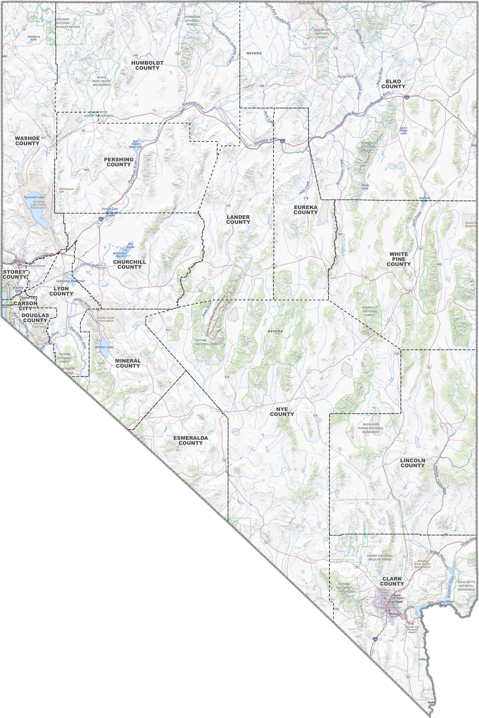
PHYSICAL MAP
Nevada Topographic County Map
Here’s a detailed look at Nevada. Our map includes county borders, main roads, lakes, rivers, and reservations so you see how it all fits together
SATELLITE IMAGERY
Nevada Satellite County Map
Nevada’s satellite view is all about its dry basins, rugged mountains, and flashes of green near rivers and cities. With county lines layered on top, it’s easy to spot where everything sits.

OUTLINE MAP
Nevada Simple County Map
Here’s a clean breakdown of Nevada’s counties. They’re labeled, outlined, and easy to read. Here, you’ll find just the basics for a quick reference.

Nevada Counties
Clark County is where the action’s at. It’s home to Las Vegas, which explains why it has more people than all the other counties combined. The bright lights, casinos, and job opportunities draw folks in. Esmeralda County has the lowest population and is mostly desert and mountains.
Most Populous: Clark County
Least Populous: Esmeralda County

Nye County is the largest when it comes to size. It’s larger than several states put together. Despite its massive area, it’s home to fewer than 50,000 people. Conversely, Storey County is the smallest, just east of Reno.
Largest Area: Nye County
Smallest Area: Storey County
Nevada’s counties have some neat stories behind them. First, Humboldt County is named after German naturalist Alexander von Humboldt. There’s also Washoe County, whose name comes from the Washoe people (the area’s original inhabitants).
From the neon-lit streets of Las Vegas to the rugged beauty of the Ruby Mountains, Nevada’s counties have more variety than you might expect.
Nevada County List
Here’s a complete list of Nevada’s counties with important details for each:
| FIPS Code | Name | Land % | Water % | Total Area (sq mi) |
|---|---|---|---|---|
| 32-001 | Churchill County | 98.1 | 1.9 | 5,024.1 |
| 32-003 | Clark County | 97.9 | 2.1 | 8,060.9 |
| 32-005 | Douglas County | 96.2 | 3.8 | 737.6 |
| 32-007 | Elko County | 99.8 | 0.2 | 17,202.2 |
| 32-009 | Esmeralda County | 99.8 | 0.2 | 3,589.0 |
| 32-011 | Eureka County | 99.9 | 0.1 | 4,179.9 |
| 32-013 | Humboldt County | 99.8 | 0.2 | 9,657.8 |
| 32-015 | Lander County | 99.5 | 0.5 | 5,519.5 |
| 32-017 | Lincoln County | 100.0 | 0.0 | 10,637.1 |
| 32-019 | Lyon County | 98.9 | 1.1 | 2,024.2 |
| 32-021 | Mineral County | 98.4 | 1.6 | 3,813.0 |
| 32-023 | Nye County | 99.9 | 0.1 | 18,198.5 |
| 32-027 | Pershing County | 99.5 | 0.5 | 6,067.4 |
| 32-029 | Storey County | 99.7 | 0.3 | 264.7 |
| 32-031 | Washoe County | 96.3 | 3.7 | 6,541.1 |
| 32-033 | White Pine County | 99.8 | 0.2 | 8,895.7 |
| 32-510 | Carson City | 92.0 | 8.0 | 157.2 |
Source: United States Census Bureau