Stafford County Map, Virginia

Stafford County Map Collection


We allow you to use our Stafford County map. Attribution is required.
Stafford County, Virginia

Stafford County is just south of Washington D.C. It’s been around since 1664, making it one of the oldest counties in Virginia. The Potomac and Rappahannock Rivers border the county.
Historians will love the fact that George Washington grew up at Ferry Farm in Stafford. The county is growing fast, with new developments springing up all over. But there’s still plenty of open space and parks to enjoy.
Stafford is the county seat and a hub of activity. You can’t beat the location because it’s close enough to D.C. It’s an easy commute, but far enough away to escape the city hustle. The people here are friendly and down-to-earth. And if you’re into craft beer, check out the local breweries. They’re making quite a name for themselves.
| Category | Details |
|---|---|
| County Name | Stafford County |
| County Seat | Stafford |
| Population | Approximately 157,000 |
| Cities, Towns, and Communities | Stafford, Falmouth, Aquia Harbour, Garrisonville, Hartwood |
| Interstates and Highways | I-95, US-1, US-17, VA-610 |
| FIPS Code | 51-179 |
| Total Area (Land and Water) | 280 sq mi (Land: 269 sq mi; Water: 11 sq mi) |
| Adjacent Counties (and Direction) | Fauquier County (Northwest), Prince William County (North), Charles County, Maryland (East), King George County (Southeast), Caroline County (South), Fredericksburg City (Southwest), Spotsylvania County (Southwest), Culpeper County (West) |
| Time Zone | Eastern Time Zone (ET) |
| State | Virginia |
| Coordinates | 38.4338° N, 77.4051° W |
| Etymology | Named after Stafford, England |
| Major Landmarks | Government Island, Aquia Church, George Washington’s Ferry Farm |
| Website | Stafford County Website |
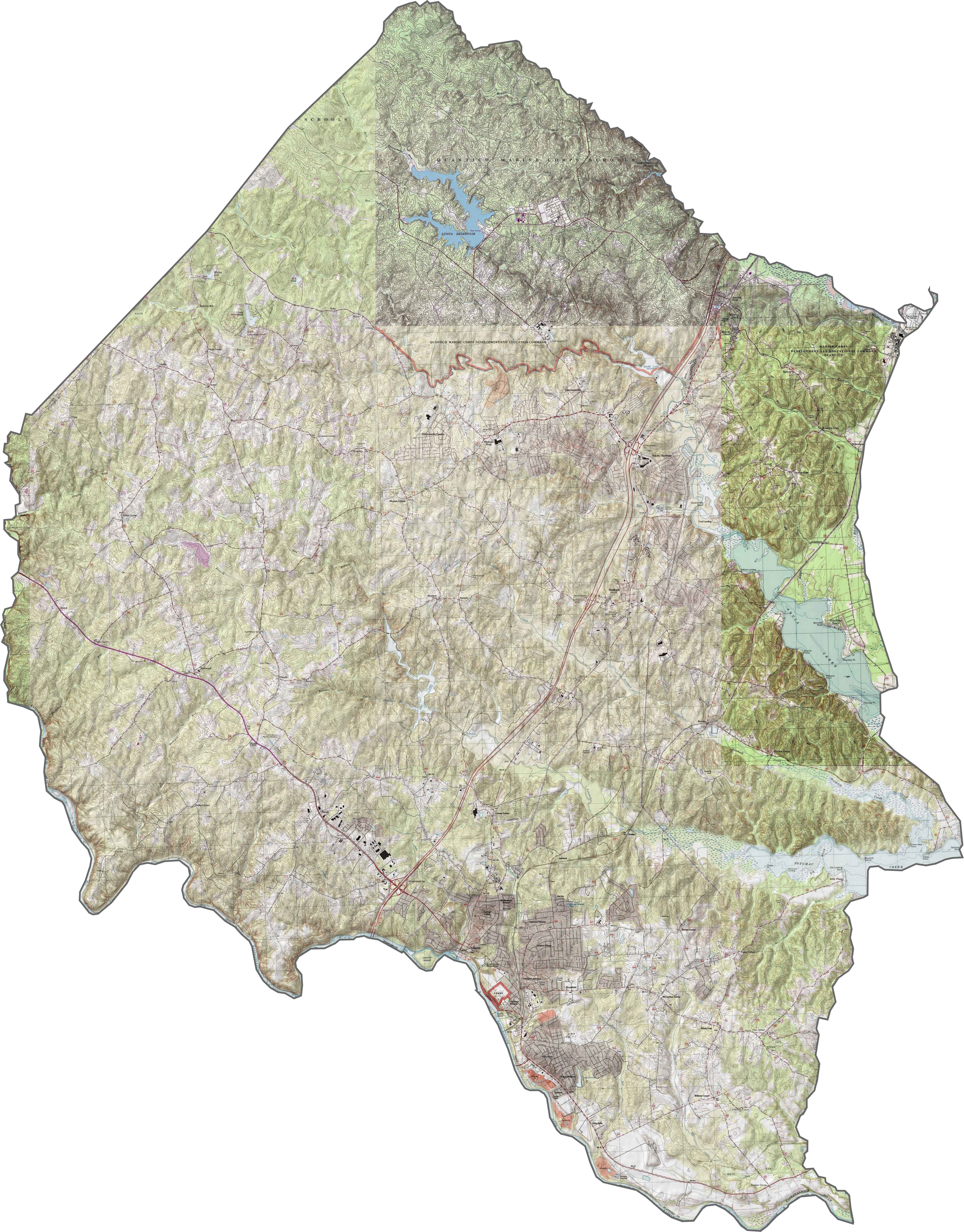
PHYSICAL MAP
Stafford County Topographic Map
Stafford County slopes gradually toward the Potomac River. The land is mostly low and rolling, with shallow ridges and wide creeks. Aquia Creek stands out as a defining feature, carving through the county on its way to the river. Lunga Reservoir also stands out in the north-central region.
TRANSPORTATION MAP
Stafford County Road Map
Interstate 95 runs straight through Stafford. However, smaller highways fan out from the main corridor, some winding toward the Potomac and others cutting through wooded stretches. Our zoom tool shows it all clearly, from interchanges to back roads.

SATELLITE IMAGERY
Stafford County Satellite Map
Stafford County is a blend of suburb and forest. Large subdivisions fill the space near I-95, but forested patches remain thick between them. The Potomac River defines the eastern edge, while creeks and small lakes add a bit of blue across the map.

OUTLINE MAP
Stafford County Blank Map
Stafford County’s shape is broad and slightly jagged. It stretches east to the Potomac River, which forms a natural border with Maryland. The river curves sharply along the edge, giving the county its distinctive eastern boundary.

Neighboring Counties
Here are the 8 neighboring counties of Stafford County:


Virginia County Map

The original cool. Virginia’s 95 counties mix old-school roots with mountain roads with Civil War footsteps. One county’s got peanuts, another has presidents. Some lean country, others lean capital.