Ada County Map, Idaho

Ada County Map Collection
We allow you to use our Ada County map. Attribution is required.
Ada County, Idaho

Ada County sits in the heart of Idaho’s Treasure Valley. Boise, the state capital, anchors the county and gives it a hip urban vibe. The Boise River cuts through town, lined with a popular greenbelt for biking and jogging.
Foothills rise up north of the city, crisscrossed with hiking trails. It’s a fast-growing area, attracting tech companies and Californians fleeing high costs. Locals complain about the growth but secretly love the new restaurants.
The suburbs sprawl out into former farmland. Meridian and Eagle are booming. Downtown Boise has a surprising food scene and decent nightlife. BSU’s blue football field is a point of pride. You can ski, mountain bike, and fly fish all on the same day here.
| Category | Details |
|---|---|
| County Name | Ada County |
| County Seat | Boise |
| Population | 550,000 |
| Cities, Towns, and Communities | Boise, Meridian, Eagle, Kuna, Garden City, Star, and more |
| Interstates and Highways | Interstate 84, U.S. Route 20, U.S. Route 26, Idaho State Highway 55 |
| FIPS Code | 16-001 |
| Total Area | 1,079 square miles (land: 1,036 sq mi; water: 43 sq mi) |
| Adjacent Counties | Gem County (Northwest), Boise County (Northeast), Elmore County (East), Owyhee County (South), Canyon County (West) |
| Time Zone | Mountain Time Zone |
| State | Idaho |
| Coordinates | 43.6° N, 116.2° W |
| Etymology | Named after Ada Riggs, a pioneer woman who was a prominent figure in early Idaho history. |
| Major Landmarks | Boise River Greenbelt, Idaho State Capitol, Boise National Forest, Julia Davis Park, Old Idaho Penitentiary |
| Website | Ada County Website |
PHYSICAL MAP
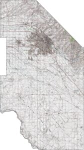
Ada County Topographic Map
Our Ada County topographic map is all about the Boise foothills. It has rolling, golden slopes that rise up behind the city. The Boise River snakes through the valley, cutting a green path through the urban sprawl. It’s the kind of map that makes you want to grab your hiking boots.
SATELLITE IMAGERY
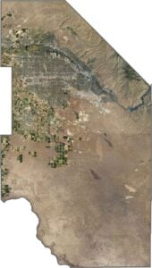
Ada County Satellite Map
From above, Ada County is a cool mix of city life and nature. Boise’s neighborhoods spread out in neat grids, while the Boise River twists through like a green thread. Up north, the foothills are a messy blend of golden grass and dark trees.

OUTLINE MAP
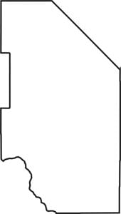
Ada County Blank Map
Ada County’s outline is kind of a wonky rectangle, with slight cuts. The southwest corner aligns with Snake River, bordering Owyhee County. It’s not perfectly straight so it’s more like someone sketched it quickly but kept it neat.

Neighboring Counties
Here are the 5 neighboring counties of Ada County:


Idaho County Map

Discover Idaho’s diverse counties. Rugged mountains. Rolling plains. Explore Boise’s heart, Teton’s wild beauty, and Shoshone’s untamed forests. Grab an Idaho County map and uncover its best-kept secrets