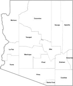
Arizona County Map

Arizona County Map Collection

We allow you to use our Arizona County map. Attribution is required.
Arizona County Maps
The Grand Canyon State is carved up into 15 counties. It’s a modest number compared to some states. But don’t let that fool you. Here’s a map of each one.


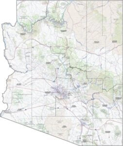
PHYSICAL MAP
Arizona Topographic County Map
Arizona’s topography shifts dramatically from low desert basins to high forested plateaus. Our map below highlights these changes in elevation with Arizona’s 15 counties overlaid on top.

SATELLITE IMAGERY
Arizona Satellite County Map
Every county looks distinct in our satellite map of Arizona. Urban areas like Phoenix and Tucson appear as wide gray spreads against the natural colors.

OUTLINE MAP
Arizona Simple County Map
No topographic shading or satellite imagery. This one is just the basics. It’s a clean way to learn where each county sits in the state.

Arizona Counties
What’s the most populous county in Arizona? You guessed it. Maricopa County is the biggest here, population-wise. It’s home to Phoenix, the state capital and a sprawling metropolis that just keeps growing. But flip the coin, and you’ve got Greenlee County. It’s Arizona’s least populous, tucked away in the state’s eastern reaches. Why so few people? Well, it’s mostly rugged mountains and old copper mines. Not exactly prime real estate, but beautiful in its own right.
Most Populous: Maricopa County
Least Populous: Greenlee County

When it comes to size, Coconino County is bigger than nine U.S. states, if you can believe it. A good chunk of the Grand Canyon calls this county home. The smallest? Santa Cruz County is here down on the Mexican border. It might be tiny, but it has character to spare, with rolling grasslands and sky islands.
Largest Area: Coconino County
Smallest Area: Santa Cruz County
The story of Arizona’s counties is an interesting one. Take Apache County, for instance. It’s named after the Native American tribe, which is perfect for the indigenous history of the area. Or Yavapai County, its name coming from a word meaning “people of the sun.” The first county? Yuma was established back in 1864 when Arizona was still just a territory.
From the Sonoran Desert to the Colorado Plateau, Arizona’s counties showcase the state’s incredible diversity. You’ve got Yuma County, where winter vegetables grow in abundance. Coconino County is home to the state’s highest peak. You’ve got places where you can ski in the morning and sweat in the desert by afternoon. It’s a state of extremes, and its counties reflect that.
Arizona County List
Here’s a complete list of Arizona’s 15 counties, with key statistics for each:
| FIPS Code | Name | Land % | Water % | Total Area (sq mi) |
|---|---|---|---|---|
| 04-001 | Apache County | 99.8 | 0.2 | 11,218.3 |
| 04-003 | Cochise County | 99.1 | 0.9 | 6,217.4 |
| 04-005 | Coconino County | 99.8 | 0.2 | 18,661.1 |
| 04-007 | Gila County | 99.2 | 0.8 | 4,795.5 |
| 04-009 | Graham County | 99.6 | 0.4 | 4,641.0 |
| 04-011 | Greenlee County | 99.7 | 0.3 | 1,847.3 |
| 04-012 | La Paz County | 99.7 | 0.3 | 4,513.7 |
| 04-013 | Maricopa County | 99.7 | 0.3 | 9,224.0 |
| 04-015 | Mohave County | 98.9 | 1.1 | 13,460.5 |
| 04-017 | Navajo County | 99.9 | 0.1 | 9,959.1 |
| 04-019 | Pima County | 100.0 | 0.0 | 9,189.2 |
| 04-021 | Pinal County | 99.8 | 0.2 | 5,374.4 |
| 04-023 | Santa Cruz County | 99.9 | 0.1 | 1,238.1 |
| 04-025 | Yavapai County | 99.9 | 0.1 | 8,127.9 |
| 04-027 | Yuma County | 99.9 | 0.1 | 5,519.1 |
Source: United States Census Bureau