New Mexico County Map

New Mexico County Map Collection


We allow you to use our New Mexico County map. Attribution is required.
New Mexico County Maps
New Mexico contains 33 counties with a mix of deserts, mountains, and rich cultural history. Click on one of its counties below.


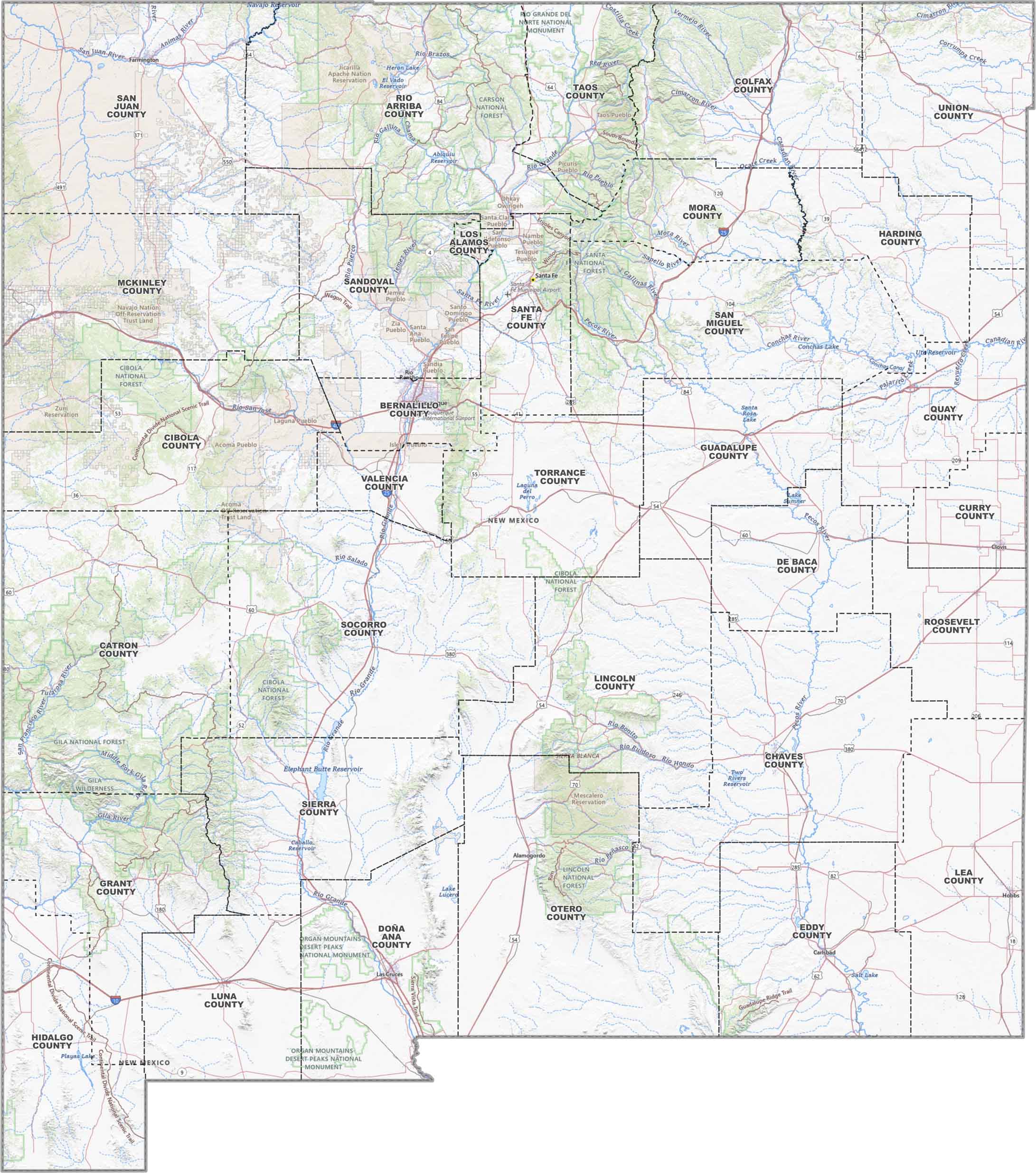
PHYSICAL MAP
New Mexico Topographic County Map
Our topographic map can help you get your bearings in New Mexico. We’ve marked counties, highways, reservations, cities, lakes, rivers and national forests.
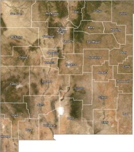
SATELLITE IMAGERY
New Mexico Satellite County Map
From above, New Mexico’s all texture. You’ll definitely see desert flats and green patches near rivers. Our satellite map keeps that raw look, with county lines added.

OUTLINE MAP
New Mexico Simple County Map
Here it is. New Mexico, broken down by county and nothing else. You get clear lines and labels so you can see New Mexico, plain and simple.

New Mexico Counties
In the state of New Mexico, Bernalillo County is the most populous county. It’s mainly because it’s home to Albuquerque, the state’s largest city. Meanwhile, the least populous is Harding County. With fewer than 700 residents, it’s a place with prairie and solitude.
Most Populous: Bernalillo County
Least Populous: Harding County

When it comes to sheer size, Catron County is largest. It extends across over 6,900 square miles, including the Gila National Forest. On the other hand, Los Alamos County is the smallest in size, yet it holds immense historical significance. It was the birthplace of the atomic bomb and the Manhattan Project.
Largest Area: Catron County
Smallest Area: Los Alamos County
Diverse in both geography and culture, New Mexico county names have intriguing origins. Taos County, for instance, is known for its art scene and Taos Pueblo. Lincoln County has a storied past, linked forever to the infamous outlaw Billy the Kid and the Lincoln County War. From the alien-themed tourism of Roswell in Chaves County to De Baca County, each county is unique. There’s a lot to explore in the Land of Enchantment.
New Mexico County List
Here’s a complete list of New Mexico’s counties, with key statistics for each:
| FIPS Code | Name | Land % | Water % | Total Area (sq mi) |
|---|---|---|---|---|
| 35-001 | Bernalillo County | 99.5 | 0.5 | 1,167.4 |
| 35-003 | Catron County | 99.9 | 0.1 | 6,929.6 |
| 35-005 | Chaves County | 99.9 | 0.1 | 6,075.0 |
| 35-006 | Cibola County | 100.0 | 0.0 | 4,542.1 |
| 35-007 | Colfax County | 99.7 | 0.3 | 3,768.1 |
| 35-009 | Curry County | 99.8 | 0.2 | 1,408.6 |
| 35-011 | De Baca County | 99.5 | 0.5 | 2,334.3 |
| 35-013 | Doña Ana County | 99.8 | 0.2 | 3,815.0 |
| 35-015 | Eddy County | 99.5 | 0.5 | 4,198.1 |
| 35-017 | Grant County | 99.9 | 0.1 | 3,967.1 |
| 35-019 | Guadalupe County | 100.0 | 0.0 | 3,030.9 |
| 35-021 | Harding County | 100.0 | 0.0 | 2,125.9 |
| 35-023 | Hidalgo County | 99.7 | 0.3 | 3,447.6 |
| 35-025 | Lea County | 99.9 | 0.1 | 4,394.7 |
| 35-027 | Lincoln County | 100.0 | 0.0 | 4,831.3 |
| 35-028 | Los Alamos County | 99.9 | 0.1 | 109.3 |
| 35-029 | Luna County | 100.0 | 0.0 | 2,965.4 |
| 35-031 | McKinley County | 99.9 | 0.1 | 5,455.9 |
| 35-033 | Mora County | 99.9 | 0.1 | 1,928.6 |
| 35-035 | Otero County | 99.8 | 0.2 | 6,626.8 |
| 35-037 | Quay County | 99.7 | 0.3 | 2,881.1 |
| 35-039 | Rio Arriba County | 99.4 | 0.6 | 5,896.2 |
| 35-041 | Roosevelt County | 99.7 | 0.3 | 2,453.2 |
| 35-043 | Sandoval County | 99.9 | 0.1 | 3,714.3 |
| 35-045 | San Juan County | 99.6 | 0.4 | 5,538.4 |
| 35-047 | San Miguel County | 99.6 | 0.4 | 4,741.3 |
| 35-049 | Santa Fe County | 99.9 | 0.1 | 1,911.4 |
| 35-051 | Sierra County | 98.7 | 1.3 | 4,238.2 |
| 35-053 | Socorro County | 100.0 | 0.0 | 6,648.2 |
| 35-055 | Taos County | 99.9 | 0.1 | 2,203.7 |
| 35-057 | Torrance County | 100.0 | 0.0 | 3,346.1 |
| 35-059 | Union County | 99.8 | 0.2 | 3,831.0 |
| 35-061 | Valencia County | 99.9 | 0.1 | 1,067.8 |
Source: United States Census Bureau