Minnesota County Map

Minnesota County Map Collection
We allow you to use our Minnesota County map. Attribution is required.
Minnesota County Maps
Minnesota has 87 counties and all of its lakes. They don’t call it the “Land of 10,000 lakes” for nothing.


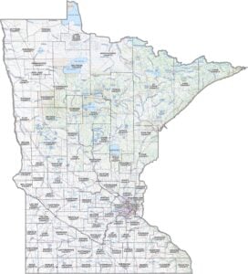
PHYSICAL MAP
Minnesota Topographic County Map
Looking for a basic layout of Minnesota? This map shows all the counties, main roads, and a few natural highlights like rivers and lakes.

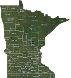
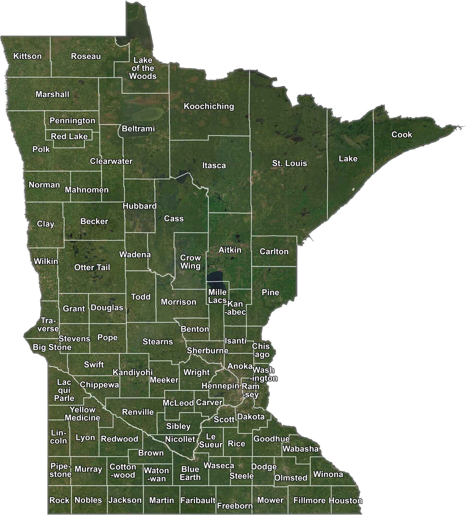
SATELLITE IMAGERY
Minnesota Satellite County Map
Get a bird’s-eye view of Minnesota with our satellite map. You’ll spot forests, lakes, and small towns spread across the state.
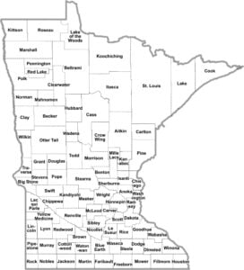
OUTLINE MAP
Minnesota Simple County Map
Here’s Minnesota, stripped down to the essentials. All you’ll see is just counties with labels. It’s a fast way to see how the state’s divided up.

Minnesota Counties
Hennepin County is where most Minnesotans call home. It’s the most populous county, and that’s mainly because of Minneapolis. Now, if you’re looking for some peace and quiet, head up to Traverse County in the western part of the state. It’s the least populous county in Minnesota because it’s mostly farmland.
Most Populous: Hennepin County
Least Populous: Traverse County

In terms of area, St. Louis County is the giant. It’s the largest county by a mile, covering a huge chunk of the Arrowhead region in northeastern Minnesota. The smallest county is Ramsey County, which is basically just St. Paul and a few suburbs. It might be small, but it has the state capital.
Largest Area: St. Louis County
Smallest Area: Ramsey County
Minnesota’s counties have some quirky stories behind them. Take Koochiching County… try saying that five times fast. Its name comes from an Ojibwe word meaning “somewhere by a lake with many bays.” Or how about Lac qui Parle County? That’s French for “the lake that speaks,” named after a nearby lake known for its echoes.
Minnesota started setting up counties pretty early on. Ramsey, Benton, and Washington counties were all established in 1849, when Minnesota was still just a territory. Below, you’ll find a table packed with details about how counties measure up on Minnesota.
Minnesota County List
Here’s a complete list of Minnesota’s counties, with key statistics for each:
| FIPS Code | Name | Land % | Water % | Total Area (sq mi) |
|---|---|---|---|---|
| 27-001 | Aitkin County | 91.3 | 8.7 | 1,995.3 |
| 27-003 | Anoka County | 94.6 | 5.4 | 446.1 |
| 27-005 | Becker County | 91.0 | 9.0 | 1,445.2 |
| 27-007 | Beltrami County | 82.0 | 18.0 | 3,055.4 |
| 27-009 | Benton County | 98.9 | 1.1 | 413.0 |
| 27-011 | Big Stone County | 94.5 | 5.5 | 528.1 |
| 27-013 | Blue Earth County | 97.7 | 2.3 | 765.6 |
| 27-015 | Brown County | 98.8 | 1.2 | 618.2 |
| 27-017 | Carlton County | 98.4 | 1.6 | 875.3 |
| 27-019 | Carver County | 94.2 | 5.8 | 376.1 |
| 27-021 | Cass County | 83.7 | 16.3 | 2,414.0 |
| 27-023 | Chippewa County | 98.9 | 1.1 | 587.8 |
| 27-025 | Chisago County | 93.8 | 6.2 | 442.4 |
| 27-027 | Clay County | 99.3 | 0.7 | 1,052.6 |
| 27-029 | Clearwater County | 97.0 | 3.0 | 1,029.8 |
| 27-031 | Cook County | 43.5 | 56.5 | 3,339.6 |
| 27-033 | Cottonwood County | 98.7 | 1.3 | 648.6 |
| 27-035 | Crow Wing County | 86.3 | 13.7 | 1,156.5 |
| 27-037 | Dakota County | 95.8 | 4.2 | 586.8 |
| 27-039 | Dodge County | 99.9 | 0.1 | 439.6 |
| 27-041 | Douglas County | 88.4 | 11.6 | 720.0 |
| 27-043 | Faribault County | 98.7 | 1.3 | 721.9 |
| 27-045 | Fillmore County | 99.9 | 0.1 | 862.1 |
| 27-047 | Freeborn County | 97.9 | 2.1 | 722.4 |
| 27-049 | Goodhue County | 97.0 | 3.0 | 780.4 |
| 27-051 | Grant County | 95.2 | 4.8 | 575.5 |
| 27-053 | Hennepin County | 91.3 | 8.7 | 606.6 |
| 27-055 | Houston County | 97.0 | 3.0 | 568.8 |
| 27-057 | Hubbard County | 92.6 | 7.4 | 999.5 |
| 27-059 | Isanti County | 96.5 | 3.5 | 451.6 |
| 27-061 | Itasca County | 91.1 | 8.9 | 2,927.9 |
| 27-063 | Jackson County | 97.7 | 2.3 | 719.2 |
| 27-065 | Kanabec County | 97.7 | 2.3 | 533.7 |
| 27-067 | Kandiyohi County | 92.5 | 7.5 | 862.3 |
| 27-069 | Kittson County | 99.6 | 0.4 | 1,103.6 |
| 27-071 | Koochiching County | 98.4 | 1.6 | 3,154.0 |
| 27-073 | Lac qui Parle County | 98.3 | 1.7 | 778.0 |
| 27-075 | Lake County | 70.5 | 29.5 | 2,990.6 |
| 27-077 | Lake of the Woods County | 72.9 | 27.1 | 1,779.5 |
| 27-079 | Le Sueur County | 94.7 | 5.3 | 473.8 |
| 27-081 | Lincoln County | 97.9 | 2.1 | 548.4 |
| 27-083 | Lyon County | 99.0 | 1.0 | 721.7 |
| 27-085 | McLeod County | 97.2 | 2.8 | 505.5 |
| 27-087 | Mahnomen County | 95.7 | 4.3 | 582.9 |
| 27-089 | Marshall County | 97.9 | 2.1 | 1,812.9 |
| 27-091 | Martin County | 97.6 | 2.4 | 729.6 |
| 27-093 | Meeker County | 94.3 | 5.7 | 644.8 |
| 27-095 | Mille Lacs County | 84.0 | 16.0 | 681.6 |
| 27-097 | Morrison County | 97.5 | 2.5 | 1,153.4 |
| 27-099 | Mower County | 100.0 | 0.0 | 711.6 |
| 27-101 | Murray County | 97.9 | 2.1 | 719.5 |
| 27-103 | Nicollet County | 96.1 | 3.9 | 467.0 |
| 27-105 | Nobles County | 99.0 | 1.0 | 722.5 |
| 27-107 | Norman County | 99.6 | 0.4 | 876.7 |
| 27-109 | Olmsted County | 99.8 | 0.2 | 654.9 |
| 27-111 | Otter Tail County | 88.6 | 11.4 | 2,224.5 |
| 27-113 | Pennington County | 99.7 | 0.3 | 618.2 |
| 27-115 | Pine County | 98.4 | 1.6 | 1,434.5 |
| 27-117 | Pipestone County | 99.8 | 0.2 | 466.0 |
| 27-119 | Polk County | 98.7 | 1.3 | 1,997.8 |
| 27-121 | Pope County | 93.4 | 6.6 | 717.1 |
| 27-123 | Ramsey County | 89.5 | 10.5 | 170.1 |
| 27-125 | Red Lake County | 100.0 | 0.0 | 432.5 |
| 27-127 | Redwood County | 99.6 | 0.4 | 881.7 |
| 27-129 | Renville County | 99.6 | 0.4 | 987.1 |
| 27-131 | Rice County | 96.1 | 3.9 | 515.9 |
| 27-133 | Rock County | 99.9 | 0.1 | 482.7 |
| 27-135 | Roseau County | 99.6 | 0.4 | 1,678.1 |
| 27-137 | St. Louis County | 91.1 | 8.9 | 6,859.5 |
| 27-139 | Scott County | 96.7 | 3.3 | 368.4 |
| 27-141 | Sherburne County | 96.0 | 4.0 | 451.0 |
| 27-143 | Sibley County | 98.0 | 2.0 | 600.5 |
| 27-145 | Stearns County | 96.6 | 3.4 | 1,390.0 |
| 27-147 | Steele County | 99.4 | 0.6 | 432.3 |
| 27-149 | Stevens County | 98.0 | 2.0 | 575.3 |
| 27-151 | Swift County | 98.7 | 1.3 | 752.2 |
| 27-153 | Todd County | 96.5 | 3.5 | 979.5 |
| 27-155 | Traverse County | 98.0 | 2.0 | 585.8 |
| 27-157 | Wabasha County | 95.2 | 4.8 | 549.5 |
| 27-159 | Wadena County | 98.7 | 1.3 | 543.2 |
| 27-161 | Waseca County | 97.8 | 2.2 | 433.0 |
| 27-163 | Washington County | 90.9 | 9.1 | 422.8 |
| 27-165 | Watonwan County | 98.9 | 1.1 | 439.7 |
| 27-167 | Wilkin County | 100.0 | 0.0 | 751.2 |
| 27-169 | Winona County | 97.6 | 2.4 | 641.6 |
| 27-171 | Wright County | 92.6 | 7.4 | 714.2 |
| 27-173 | Yellow Medicine County | 99.5 | 0.5 | 763.2 |
Source: United States Census Bureau