Colorado County Map

Colorado County Map Collection
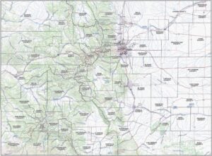


We allow you to use our Colorado County map. Attribution is required.
Colorado County Maps
Colorado contains 64 counties. Each county captures the essence of the Centennial State. You’ve got your high rollers and your no-stoplight towns, all mixed up in one rectangular state.


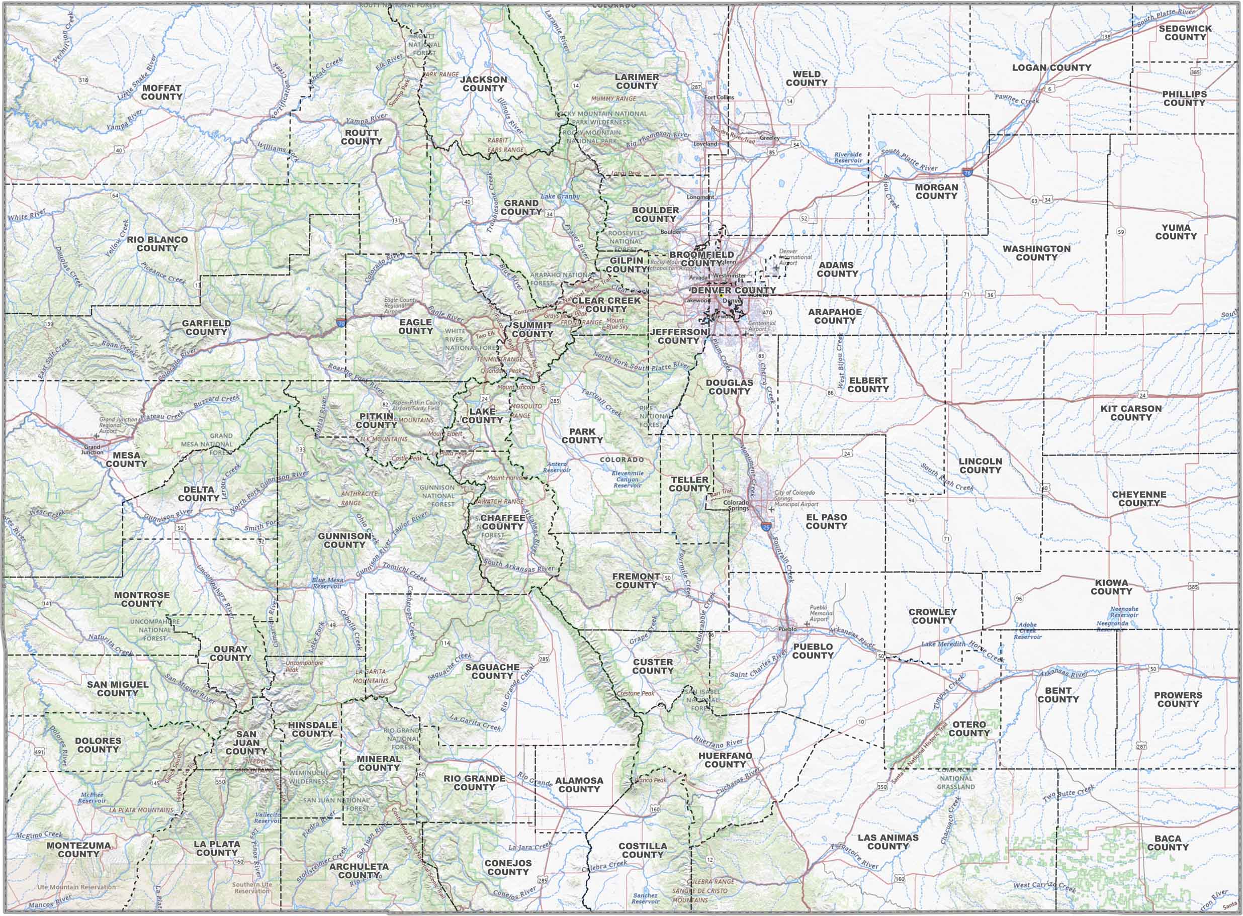
PHYSICAL MAP
Colorado Topographic County Map
Check out Colorado’s wild terrain with our topographic map. It shows off the jagged Rockies, high plains, and everything in between. County lines keep things nice and organized.
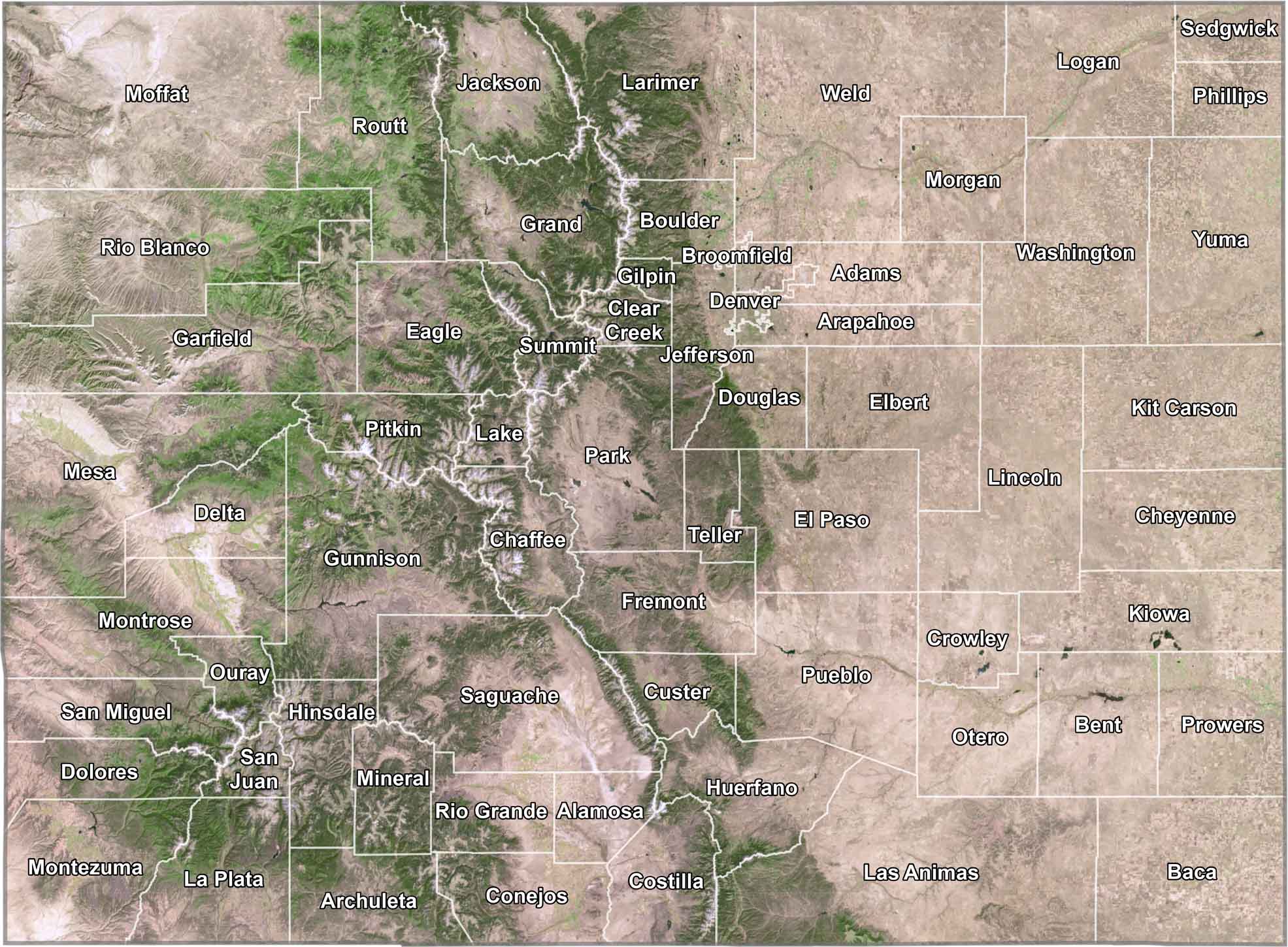
SATELLITE IMAGERY
Colorado Satellite County Map
Colorado’s 64 counties span from the Great Plains in the east to the Rocky Mountains in the west. Our satellite map of Colorado displays how county boundaries follow natural features like mountain ridges and river valleys.
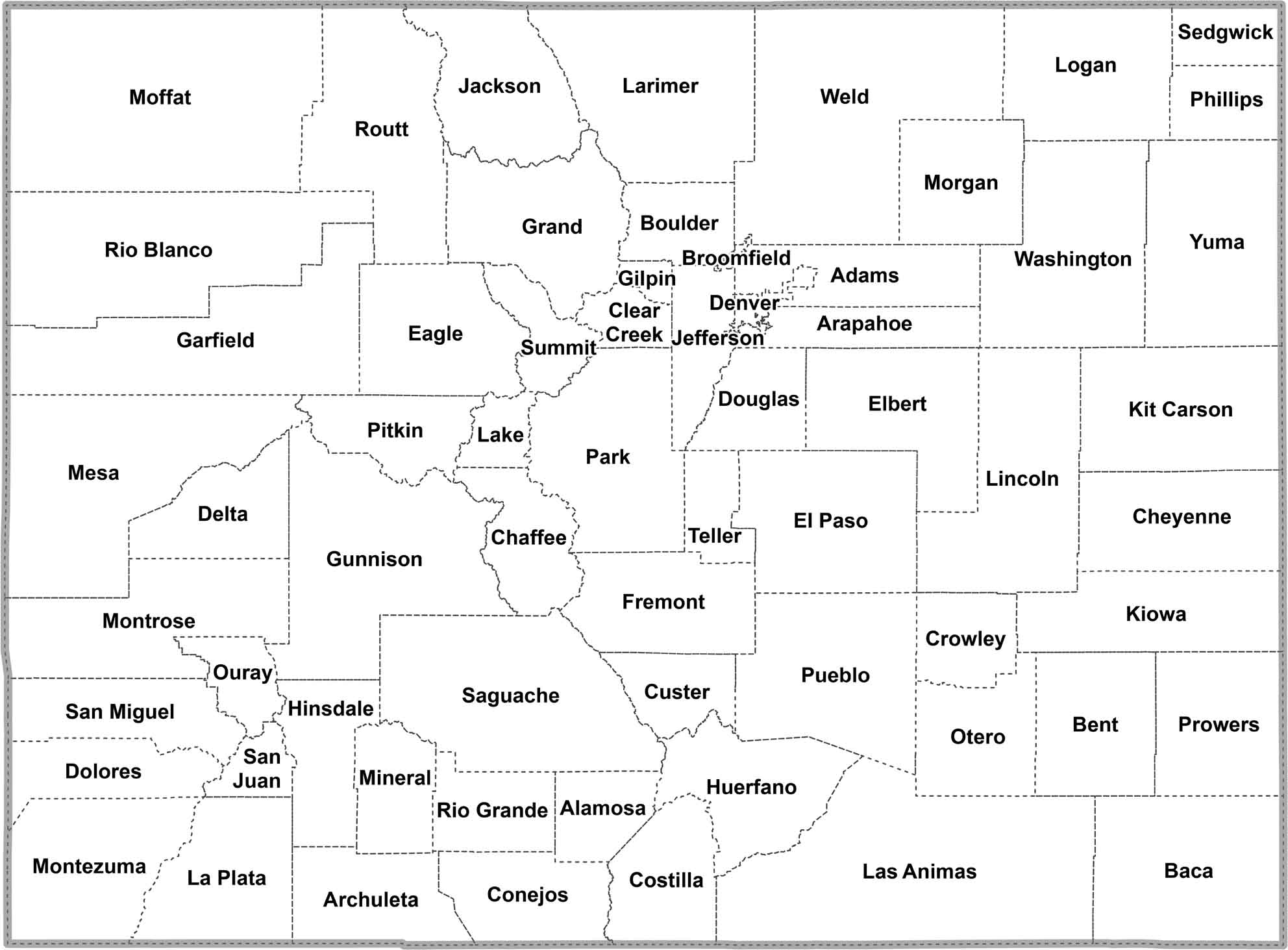
OUTLINE MAP
Colorado Simple County Map
This simplified county map of Colorado displays all 64 counties with clean boundary lines. In black and white, you see how they connect to form Colorado’s distinctive rectangular shape.
Colorado Counties
Denver County is the big cheese here, population-wise. It’s a city and county rolled into one, perched a mile high and packed with people. The Rocky Mountain backdrop isn’t bad either. But let’s talk about San Juan County, way up in the San Juan Mountains. It’s Colorado’s least populous, with barely 700 people to its name.
Most Populous: Denver County
Least Populous: San Juan County

Las Animas County stretches out as Colorado’s largest county. It covers more ground than Rhode Island, with canyons, mesas, and the Spanish Peaks. Broomfield County is Colorado’s smallest and newest county, carved out of four others in 2001.
Largest Area: Los Animas County
Smallest Area: Broomfield County
Colorado’s counties are like a history book of the American West. Take Kit Carson County, named after the famous frontiersman. Or Pueblo County, its name a nod to the area’s Native American and Spanish heritage. The first county? Arapahoe was established in 1861.
From the ski slopes of Summit County to the sand dunes of Alamosa County, Colorado’s counties each bring something unique to the table. You’ve got Mesa County with its fruit orchards and red rock canyons. Then, there’s Weld County with its oil wells and farmland. Each county has its own vibe. Only some are part of Colorado’s high-altitude.
Colorado County List
Get to know the 64 counties of Colorado with our table below:
| FIPS Code | Name | Land % | Water % | Total Area (sq mi) |
|---|---|---|---|---|
| 08-001 | Adams County | 98.5 | 1.5 | 1,183.4 |
| 08-003 | Alamosa County | 99.9 | 0.1 | 723.3 |
| 08-005 | Arapahoe County | 99.1 | 0.9 | 805.5 |
| 08-007 | Archuleta County | 99.6 | 0.4 | 1,355.4 |
| 08-009 | Baca County | 99.9 | 0.1 | 2,557.3 |
| 08-011 | Bent County | 98.2 | 1.8 | 1,541.1 |
| 08-013 | Boulder County | 98.1 | 1.9 | 740.5 |
| 08-014 | Broomfield County | 98.4 | 1.6 | 33.5 |
| 08-015 | Chaffee County | 99.8 | 0.2 | 1,014.9 |
| 08-017 | Cheyenne County | 99.8 | 0.2 | 1,781.4 |
| 08-019 | Clear Creek County | 99.7 | 0.3 | 396.5 |
| 08-021 | Conejos County | 99.7 | 0.3 | 1,291.0 |
| 08-023 | Costilla County | 99.7 | 0.3 | 1,231.0 |
| 08-025 | Crowley County | 98.4 | 1.6 | 800.3 |
| 08-027 | Custer County | 99.8 | 0.2 | 739.9 |
| 08-029 | Delta County | 99.4 | 0.6 | 1,148.6 |
| 08-031 | Denver County | 98.9 | 1.1 | 154.9 |
| 08-033 | Dolores County | 99.9 | 0.1 | 1,068.2 |
| 08-035 | Douglas County | 99.7 | 0.3 | 842.9 |
| 08-037 | Eagle County | 99.6 | 0.4 | 1,691.8 |
| 08-039 | Elbert County | 100.0 | 0.0 | 1,851.0 |
| 08-041 | El Paso County | 99.9 | 0.1 | 2,129.6 |
| 08-043 | Fremont County | 99.9 | 0.1 | 1,533.9 |
| 08-045 | Garfield County | 99.7 | 0.3 | 2,955.8 |
| 08-047 | Gilpin County | 99.8 | 0.2 | 150.3 |
| 08-049 | Grand County | 98.8 | 1.2 | 1,869.6 |
| 08-051 | Gunnison County | 99.4 | 0.6 | 3,259.6 |
| 08-053 | Hinsdale County | 99.5 | 0.5 | 1,123.1 |
| 08-055 | Huerfano County | 99.9 | 0.1 | 1,593.3 |
| 08-057 | Jackson County | 99.6 | 0.4 | 1,621.0 |
| 08-059 | Jefferson County | 98.7 | 1.3 | 774.1 |
| 08-061 | Kiowa County | 99.0 | 1.0 | 1,786.0 |
| 08-063 | Kit Carson County | 100.0 | 0.0 | 2,161.7 |
| 08-065 | Lake County | 98.2 | 1.8 | 383.9 |
| 08-067 | La Plata County | 99.4 | 0.6 | 1,699.6 |
| 08-069 | Larimer County | 98.5 | 1.5 | 2,634.0 |
| 08-071 | Las Animas County | 99.9 | 0.1 | 4,775.6 |
| 08-073 | Lincoln County | 99.7 | 0.3 | 2,586.5 |
| 08-075 | Logan County | 99.7 | 0.3 | 1,844.9 |
| 08-077 | Mesa County | 99.6 | 0.4 | 3,341.1 |
| 08-079 | Mineral County | 99.8 | 0.2 | 877.8 |
| 08-081 | Moffat County | 99.8 | 0.2 | 4,750.9 |
| 08-083 | Montezuma County | 99.5 | 0.5 | 2,039.8 |
| 08-085 | Montrose County | 99.9 | 0.1 | 2,242.8 |
| 08-087 | Morgan County | 99.0 | 1.0 | 1,293.9 |
| 08-089 | Otero County | 99.4 | 0.6 | 1,269.7 |
| 08-091 | Ouray County | 99.9 | 0.1 | 542.2 |
| 08-093 | Park County | 99.2 | 0.8 | 2,210.7 |
| 08-095 | Phillips County | 100.0 | 0.0 | 688.0 |
| 08-097 | Pitkin County | 99.7 | 0.3 | 973.2 |
| 08-099 | Prowers County | 99.6 | 0.4 | 1,644.3 |
| 08-101 | Pueblo County | 99.5 | 0.5 | 2,397.8 |
| 08-103 | Rio Blanco County | 99.9 | 0.1 | 3,222.8 |
| 08-105 | Rio Grande County | 100.0 | 0.0 | 912.3 |
| 08-107 | Routt County | 99.7 | 0.3 | 2,368.1 |
| 08-109 | Saguache County | 99.9 | 0.1 | 3,170.3 |
| 08-111 | San Juan County | 99.8 | 0.2 | 388.3 |
| 08-113 | San Miguel County | 99.8 | 0.2 | 1,288.7 |
| 08-115 | Sedgwick County | 99.8 | 0.2 | 549.4 |
| 08-117 | Summit County | 98.2 | 1.8 | 619.3 |
| 08-119 | Teller County | 99.7 | 0.3 | 558.9 |
| 08-121 | Washington County | 99.8 | 0.2 | 2,523.9 |
| 08-123 | Weld County | 99.2 | 0.8 | 4,016.7 |
| 08-125 | Yuma County | 99.8 | 0.2 | 2,368.7 |
Source: United States Census Bureau