Georgia County Map

Georgia County Map Collection

We allow you to use our Georgia County map. Attribution is required.
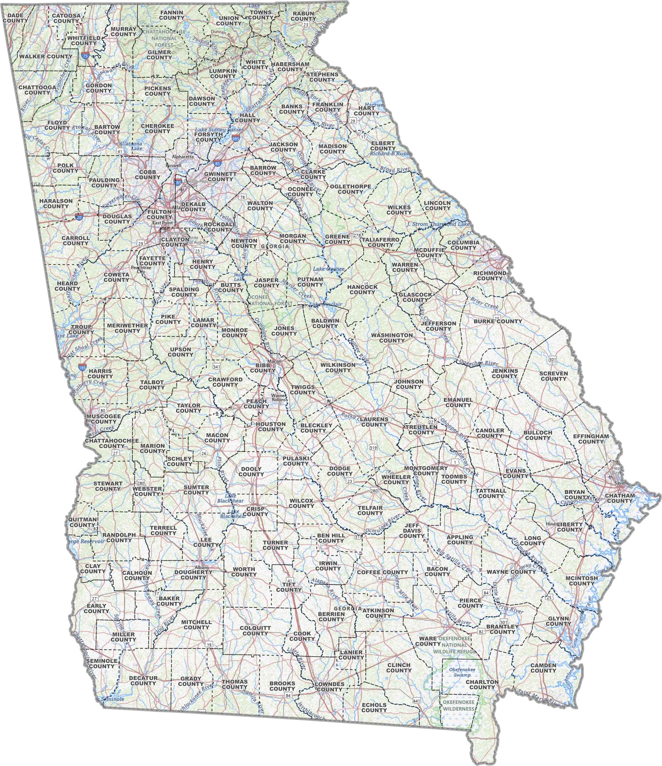
Georgia County Maps
The Peach State is carved up into a whopping 159 counties. Yep, you heard that right… 159! It’s the second most only to Texas in county count.


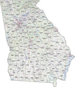
PHYSICAL MAP
Georgia Topographic County Map
Georgia’s land rises from coastal plains in the southeast to the Appalachian foothills in the north. This map shows those elevation changes, county by county.
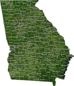
SATELLITE IMAGERY
Georgia Satellite County Map
Our satellite map of Georgia highlights forests, farmland, and urban areas all in one county map. Every county has a different texture from above.

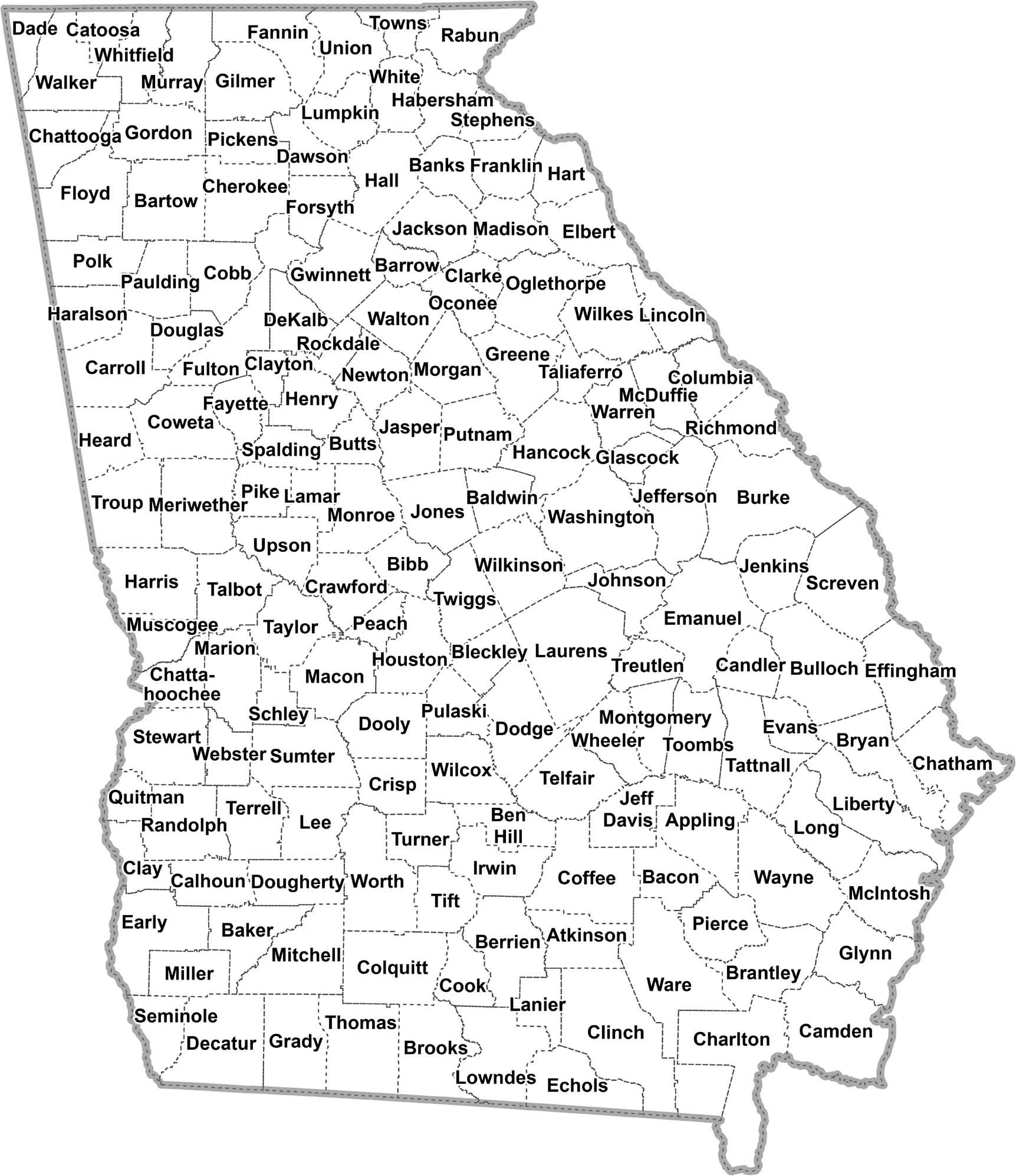
OUTLINE MAP
Georgia Simple County Map
Our clean, simple map shows Georgia’s counties with easy-to-read labels and boundaries. It’s just the layout of the state with county boundaries. Plain and simple.
Georgia Counties
Georgia’s 159 counties are pretty wild when you think about it. It’s kinda funny because Georgia isn’t even close to being the biggest state. But all these counties make sense when you look at the state’s diverse landscape. Georgia is truly a big mixed bag of terrain.

For the most populous, Fulton County takes the crown and it’s no surprise why. Atlanta, the state capital sits right in the middle of it. For least populous, there’s Taliaferro County, with barely 1,500 people calling it home. It’s mostly rural, without any big cities or attractions to draw people in.
Most Populous: Fulton County
Least Populous: Taliaferro County
When it comes to size though, Ware County is the biggest. It extends over 900 square miles in southeast Georgia. It has the northern part of the Okefenokee Swamp, which is pretty cool. The smallest? That’d be Clarke County, home to Athens and the University of Georgia. It’s only 121 square miles.
Largest Area: Ware County
Smallest Area: Clarke County
Now, here’s a fun fact: Georgia’s counties have some interesting origins. Many are named after Revolutionary War heroes or important political figures. The first county, Richmond County, was established way back in 1777. Yep, it’s older than the country itself.
From the mountains to the coast, Georgia’s counties are like a big ol’ family reunion. Some you love, some you tolerate, and some you pretend aren’t related to you. But somehow, it all works out in the end, usually over a plate of barbecue and sweet tea.
Georgia County List
Here’s a list of Georgia’s counties with important attributes:
| FIPS Code | Name | Land % | Water % | Total Area (sq mi) |
|---|---|---|---|---|
| 13-001 | Appling County | 99.2 | 0.8 | 512.3 |
| 13-003 | Atkinson County | 99.5 | 0.5 | 344.5 |
| 13-005 | Bacon County | 99.4 | 0.6 | 285.8 |
| 13-007 | Baker County | 97.9 | 2.1 | 349.1 |
| 13-009 | Baldwin County | 96.4 | 3.6 | 268.3 |
| 13-011 | Banks County | 99.2 | 0.8 | 233.8 |
| 13-013 | Barrow County | 98.8 | 1.2 | 162.9 |
| 13-015 | Bartow County | 97.8 | 2.2 | 470.1 |
| 13-017 | Ben Hill County | 98.5 | 1.5 | 253.9 |
| 13-019 | Berrien County | 99.0 | 1.0 | 457.9 |
| 13-021 | Bibb County | 97.8 | 2.2 | 254.9 |
| 13-023 | Bleckley County | 98.5 | 1.5 | 219.1 |
| 13-025 | Brantley County | 99.1 | 0.9 | 447.2 |
| 13-027 | Brooks County | 99.1 | 0.9 | 497.8 |
| 13-029 | Bryan County | 96.3 | 3.7 | 454.5 |
| 13-031 | Bulloch County | 98.2 | 1.8 | 688.6 |
| 13-033 | Burke County | 99.0 | 1.0 | 835.0 |
| 13-035 | Butts County | 97.7 | 2.3 | 188.0 |
| 13-037 | Calhoun County | 98.9 | 1.1 | 283.6 |
| 13-039 | Camden County | 80.6 | 19.4 | 781.8 |
| 13-043 | Candler County | 97.7 | 2.3 | 248.9 |
| 13-045 | Carroll County | 99.1 | 0.9 | 503.8 |
| 13-047 | Catoosa County | 99.8 | 0.2 | 162.5 |
| 13-049 | Charlton County | 99.7 | 0.3 | 782.4 |
| 13-051 | Chatham County | 68.8 | 31.2 | 630.0 |
| 13-053 | Chattahoochee County | 99.0 | 1.0 | 251.2 |
| 13-055 | Chattooga County | 99.9 | 0.1 | 313.5 |
| 13-057 | Cherokee County | 96.9 | 3.1 | 434.4 |
| 13-059 | Clarke County | 98.5 | 1.5 | 121.0 |
| 13-061 | Clay County | 89.9 | 10.1 | 217.2 |
| 13-063 | Clayton County | 98.1 | 1.9 | 144.4 |
| 13-065 | Clinch County | 98.9 | 1.1 | 824.0 |
| 13-067 | Cobb County | 98.6 | 1.4 | 344.6 |
| 13-069 | Coffee County | 98.3 | 1.7 | 602.6 |
| 13-071 | Colquitt County | 98.3 | 1.7 | 556.6 |
| 13-073 | Columbia County | 94.3 | 5.7 | 307.6 |
| 13-075 | Cook County | 97.9 | 2.1 | 233.2 |
| 13-077 | Coweta County | 98.9 | 1.1 | 445.8 |
| 13-079 | Crawford County | 99.5 | 0.5 | 326.5 |
| 13-081 | Crisp County | 97.1 | 2.9 | 280.9 |
| 13-083 | Dade County | 99.9 | 0.1 | 174.2 |
| 13-085 | Dawson County | 98.3 | 1.7 | 214.4 |
| 13-087 | Decatur County | 95.8 | 4.2 | 623.2 |
| 13-089 | DeKalb County | 98.7 | 1.3 | 271.2 |
| 13-091 | Dodge County | 98.6 | 1.4 | 503.1 |
| 13-093 | Dooly County | 98.8 | 1.2 | 397.3 |
| 13-095 | Dougherty County | 98.2 | 1.8 | 334.6 |
| 13-097 | Douglas County | 99.5 | 0.5 | 201.1 |
| 13-099 | Early County | 99.3 | 0.7 | 516.3 |
| 13-101 | Echols County | 99.9 | 0.1 | 420.7 |
| 13-103 | Effingham County | 99.1 | 0.9 | 482.9 |
| 13-105 | Elbert County | 93.8 | 6.2 | 374.2 |
| 13-107 | Emanuel County | 98.6 | 1.4 | 690.2 |
| 13-109 | Evans County | 97.9 | 2.1 | 186.9 |
| 13-111 | Fannin County | 98.7 | 1.3 | 392.3 |
| 13-113 | Fayette County | 97.5 | 2.5 | 199.3 |
| 13-115 | Floyd County | 98.3 | 1.7 | 518.5 |
| 13-117 | Forsyth County | 90.9 | 9.1 | 247.1 |
| 13-119 | Franklin County | 98.2 | 1.8 | 266.5 |
| 13-121 | Fulton County | 98.6 | 1.4 | 534.3 |
| 13-123 | Gilmer County | 98.9 | 1.1 | 431.0 |
| 13-125 | Glascock County | 99.5 | 0.5 | 144.5 |
| 13-127 | Glynn County | 71.7 | 28.3 | 585.2 |
| 13-129 | Gordon County | 99.4 | 0.6 | 358.0 |
| 13-131 | Grady County | 98.7 | 1.3 | 460.3 |
| 13-133 | Greene County | 95.4 | 4.6 | 406.2 |
| 13-135 | Gwinnett County | 98.6 | 1.4 | 436.8 |
| 13-137 | Habersham County | 99.2 | 0.8 | 279.1 |
| 13-139 | Hall County | 91.5 | 8.5 | 429.3 |
| 13-141 | Hancock County | 98.6 | 1.4 | 477.8 |
| 13-143 | Haralson County | 99.6 | 0.4 | 283.2 |
| 13-145 | Harris County | 98.1 | 1.9 | 473.0 |
| 13-147 | Hart County | 90.5 | 9.5 | 256.9 |
| 13-149 | Heard County | 98.3 | 1.7 | 301.1 |
| 13-151 | Henry County | 97.6 | 2.4 | 326.5 |
| 13-153 | Houston County | 99.0 | 1.0 | 379.9 |
| 13-155 | Irwin County | 97.7 | 2.3 | 362.8 |
| 13-157 | Jackson County | 99.0 | 1.0 | 343.1 |
| 13-159 | Jasper County | 98.6 | 1.4 | 373.5 |
| 13-161 | Jeff Davis County | 98.7 | 1.3 | 335.4 |
| 13-163 | Jefferson County | 99.4 | 0.6 | 529.7 |
| 13-165 | Jenkins County | 98.5 | 1.5 | 352.5 |
| 13-167 | Johnson County | 98.8 | 1.2 | 306.6 |
| 13-169 | Jones County | 99.6 | 0.4 | 395.4 |
| 13-171 | Lamar County | 98.7 | 1.3 | 185.8 |
| 13-173 | Lanier County | 98.4 | 1.6 | 199.8 |
| 13-175 | Laurens County | 98.6 | 1.4 | 818.5 |
| 13-177 | Lee County | 98.4 | 1.6 | 361.8 |
| 13-179 | Liberty County | 85.7 | 14.3 | 602.5 |
| 13-181 | Lincoln County | 81.8 | 18.2 | 257.3 |
| 13-183 | Long County | 99.2 | 0.8 | 403.8 |
| 13-185 | Lowndes County | 97.4 | 2.6 | 510.6 |
| 13-187 | Lumpkin County | 99.6 | 0.4 | 284.2 |
| 13-189 | McDuffie County | 96.6 | 3.4 | 266.4 |
| 13-191 | McIntosh County | 75.2 | 24.8 | 573.9 |
| 13-193 | Macon County | 98.7 | 1.3 | 406.0 |
| 13-195 | Madison County | 98.9 | 1.1 | 285.6 |
| 13-197 | Marion County | 99.6 | 0.4 | 367.5 |
| 13-199 | Meriwether County | 99.2 | 0.8 | 505.4 |
| 13-201 | Miller County | 99.6 | 0.4 | 283.7 |
| 13-205 | Mitchell County | 99.7 | 0.3 | 513.8 |
| 13-207 | Monroe County | 99.5 | 0.5 | 398.3 |
| 13-209 | Montgomery County | 98.5 | 1.5 | 244.7 |
| 13-211 | Morgan County | 98.0 | 2.0 | 354.6 |
| 13-213 | Murray County | 99.4 | 0.6 | 346.7 |
| 13-215 | Muscogee County | 97.9 | 2.1 | 221.0 |
| 13-217 | Newton County | 98.0 | 2.0 | 279.2 |
| 13-219 | Oconee County | 98.9 | 1.1 | 186.4 |
| 13-221 | Oglethorpe County | 99.3 | 0.7 | 442.0 |
| 13-223 | Paulding County | 99.3 | 0.7 | 314.3 |
| 13-225 | Peach County | 99.3 | 0.7 | 151.3 |
| 13-227 | Pickens County | 99.7 | 0.3 | 232.7 |
| 13-229 | Pierce County | 99.2 | 0.8 | 343.2 |
| 13-231 | Pike County | 98.5 | 1.5 | 219.4 |
| 13-233 | Polk County | 99.4 | 0.6 | 312.1 |
| 13-235 | Pulaski County | 99.2 | 0.8 | 251.2 |
| 13-237 | Putnam County | 95.6 | 4.4 | 360.7 |
| 13-239 | Quitman County | 94.2 | 5.8 | 160.6 |
| 13-241 | Rabun County | 98.2 | 1.8 | 377.0 |
| 13-243 | Randolph County | 99.4 | 0.6 | 430.9 |
| 13-245 | Richmond County | 98.7 | 1.3 | 328.6 |
| 13-247 | Rockdale County | 98.3 | 1.7 | 132.1 |
| 13-249 | Schley County | 99.5 | 0.5 | 167.8 |
| 13-251 | Screven County | 98.5 | 1.5 | 655.9 |
| 13-253 | Seminole County | 92.6 | 7.4 | 256.6 |
| 13-255 | Spalding County | 98.2 | 1.8 | 199.6 |
| 13-257 | Stephens County | 97.3 | 2.7 | 184.2 |
| 13-259 | Stewart County | 99.0 | 1.0 | 463.6 |
| 13-261 | Sumter County | 98.0 | 2.0 | 492.6 |
| 13-263 | Talbot County | 99.1 | 0.9 | 394.8 |
| 13-265 | Taliaferro County | 99.6 | 0.4 | 195.3 |
| 13-267 | Tattnall County | 98.5 | 1.5 | 488.3 |
| 13-269 | Taylor County | 99.2 | 0.8 | 379.7 |
| 13-271 | Telfair County | 98.5 | 1.5 | 444.0 |
| 13-273 | Terrell County | 99.4 | 0.6 | 337.7 |
| 13-275 | Thomas County | 98.6 | 1.4 | 552.2 |
| 13-277 | Tift County | 97.1 | 2.9 | 268.8 |
| 13-279 | Toombs County | 98.1 | 1.9 | 371.0 |
| 13-281 | Towns County | 96.9 | 3.1 | 171.8 |
| 13-283 | Treutlen County | 98.5 | 1.5 | 202.4 |
| 13-285 | Troup County | 92.8 | 7.2 | 446.0 |
| 13-287 | Turner County | 98.4 | 1.6 | 290.0 |
| 13-289 | Twiggs County | 99.1 | 0.9 | 362.6 |
| 13-291 | Union County | 97.9 | 2.1 | 329.1 |
| 13-293 | Upson County | 98.8 | 1.2 | 327.6 |
| 13-295 | Walker County | 99.9 | 0.1 | 447.0 |
| 13-297 | Walton County | 99.0 | 1.0 | 330.0 |
| 13-299 | Ware County | 99.0 | 1.0 | 908.0 |
| 13-301 | Warren County | 99.2 | 0.8 | 286.7 |
| 13-303 | Washington County | 99.1 | 0.9 | 684.4 |
| 13-305 | Wayne County | 98.9 | 1.1 | 648.8 |
| 13-307 | Webster County | 99.6 | 0.4 | 210.3 |
| 13-309 | Wheeler County | 98.4 | 1.6 | 300.3 |
| 13-311 | White County | 99.4 | 0.6 | 242.3 |
| 13-313 | Whitfield County | 99.8 | 0.2 | 291.1 |
| 13-315 | Wilcox County | 98.9 | 1.1 | 382.1 |
| 13-317 | Wilkes County | 99.0 | 1.0 | 474.1 |
| 13-319 | Wilkinson County | 99.4 | 0.6 | 451.9 |
| 13-321 | Worth County | 99.3 | 0.7 | 574.8 |
Source: United States Census Bureau